Fushan geodata
Fushan (Guangdong) is a seat of a fourth-order administrative division; located in China in Asia/Shanghai (GMT+8) time zone. In our database, there are 1268 cities with bigger population. Compared to other cities in China, 90.8% of cities are located further ↑North; 65.4% of cities are located further ←West and 83.4% of cities have higher elevation than Fushan. Note1


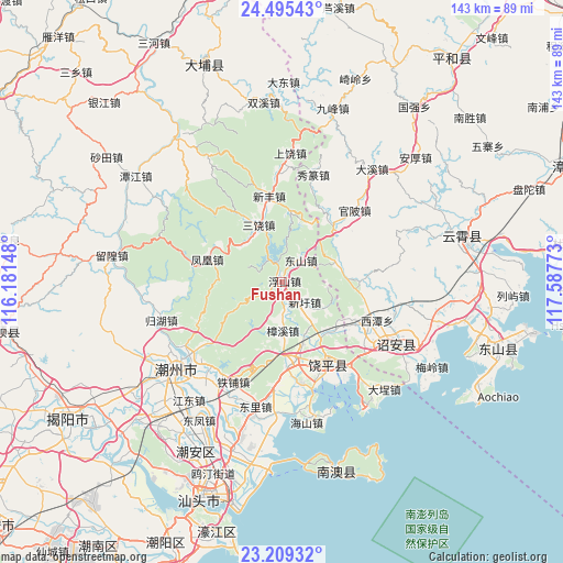
Fushan GPS coordinates[2]
23° 51' 14.292" North, 116° 53' 4.56" East
| Map corner | latitude | longitude |
|---|---|---|
| Upper-left | 24.49543°, | 116.18148° |
| Center: | 23.85397°, | 116.8846° |
| Lower-right: | 23.20932°, | 117.58773° |
| Map W x H: | 143×143 km | = 88.9×88.9mi |
| max Lat: | 53.31946° ⇑90.8% North |
| Fushan: | 23.85397° |
| min Lat: | ⇓9.2% South 18.22056° |
| min Long | Fushan | max Long |
| 75.07348° | 116.8846° | 134.28917° |
| W 65.4%⇐ | ⇒34.6% E |
Elevation
Elevation of Fushan is 19 m = 62 ft, and this is 465.8 m = 1528 ft below average elevation for this country.
| Max E: |
5622 m = 18445 ft | 83.4% |
| Avg. | 484.8 m = 1591 ft | |
| Fushan | 19 m = 62 ft | |
Min E: |
-3 m = -10 ft | 16.6% |
See also: China elevation on elevation.city.
Geographical zone
Fushan is located in North temperate zone (between Tropic of Cancer and the Arctic Circle). Distance of this Northern Tropic circle is 46.4 km =28.8 mi to South.| Distance of | km | miles | from Fushan |
|---|---|---|---|
| North Pole | 7354.7 | 4570 | to North |
| Arctic Circle | 4748.9 | 2950.8 | to North |
| Tropic Cancer | 46.4 | 28.8 | to South |
| Equator | 2652.3 | 1648.1 | to South |


Nearby cities:
15 places around Fushan: (largest is in red/bold)
• Dongshan
7.6 km =4.7 mi,  36°
36°
• Fenghuang
19.7 km =12.2 mi,  287°
287°
• Fubin
3 km =1.9 mi,  249°
249°
• Gaotang
15.6 km =9.7 mi,  156°
156°
• Jianrao
18.6 km =11.6 mi,  7°
7°
• Jingbaoshan
22.1 km =13.7 mi,  103°
103°
• Lianrao
16.4 km =10.2 mi,  143°
143°
• Qiandong
19.7 km =12.2 mi,  173°
173°
• Sanrao
15.9 km =9.9 mi,  336°
336°
• Taiping
14.2 km =8.8 mi,  68°
68°
• Tangxi
5.7 km =3.5 mi, 337°
• Xiage
20.2 km =12.6 mi, 39°
• Xintang
14.8 km =9.2 mi,  312°
312°
• Xinxu
7 km =4.3 mi,  126°
126°
• Zhangxi
12.3 km =7.6 mi,  179°
179°
Sources, notices
• [Note1] Compared only with cities in China existing in our database
• [Src1] Map data: © OpenStreetMap contributors (CC-BY-SA)
• [Src2] Other city data from geonames.org with taken over terms of usage.
• [Src3] Geographical zone / Annual Mean Temperature by Robert A. Rohde @ Wikipedia
