Dongshan geodata
Dongshan (Guangdong) is a seat of a fourth-order administrative division; located in China in Asia/Shanghai (GMT+8) time zone. In our database, there are 1268 cities with bigger population. Compared to other cities in China, 90.7% of cities are located further ↑North; 65.6% of cities are located further ←West and 76.2% of cities have higher elevation than Dongshan. Note1


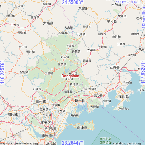
Dongshan GPS coordinates[2]
23° 54' 31.86" North, 116° 55' 43.968" East
| Map corner | latitude | longitude |
|---|---|---|
| Upper-left | 24.55003°, | 116.22576° |
| Center: | 23.90885°, | 116.92888° |
| Lower-right: | 23.26447°, | 117.63201° |
| Map W x H: | 142.9×142.9 km | = 88.8×88.8mi |
| max Lat: | 53.31946° ⇑90.7% North |
| Dongshan: | 23.90885° |
| min Lat: | ⇓9.3% South 18.22056° |
| min Long | Dongshan | max Long |
| 75.07348° | 116.92888° | 134.28917° |
| W 65.6%⇐ | ⇒34.4% E |
Elevation
Elevation of Dongshan is 34 m = 112 ft, and this is 450.8 m = 1479 ft below average elevation for this country.
| Max E: |
5622 m = 18445 ft | 76.2% |
| Avg. | 484.8 m = 1591 ft | |
| Dongshan | 34 m = 112 ft | |
Min E: |
-3 m = -10 ft | 23.8% |
See also: China elevation on elevation.city.
Geographical zone
Dongshan is located in North temperate zone (between Tropic of Cancer and the Arctic Circle). Distance of this Northern Tropic circle is 52.5 km =32.6 mi to South.| Distance of | km | miles | from Dongshan |
|---|---|---|---|
| North Pole | 7348.6 | 4566.2 | to North |
| Arctic Circle | 4742.8 | 2947 | to North |
| Tropic Cancer | 52.5 | 32.6 | to South |
| Equator | 2658.4 | 1651.9 | to South |


Nearby cities:
15 places around Dongshan: (largest is in red/bold)
• Dongpu
19.2 km =11.9 mi,  97°
97°
• Fubin
10.2 km =6.3 mi,  225°
225°
• Fushan
7.6 km =4.7 mi,  216°
216°
• Gaotang
20.5 km =12.7 mi,  175°
175°
• Jianrao
12.4 km =7.7 mi,  350°
350°
• Jingbaoshan
20.4 km =12.7 mi,  123°
123°
• Lianrao
20 km =12.4 mi,  164°
164°
• Sanrao
13.7 km =8.5 mi,  308°
308°
• Taiping
8.8 km =5.5 mi, 95°
• Tangxi
6.8 km =4.2 mi,  263°
263°
• Xiage
12.6 km =7.8 mi,  41°
41°
• Xinfeng
17.5 km =10.9 mi,  334°
334°
• Xintang
15.9 km =9.9 mi,  284°
284°
• Xinxu
10.4 km =6.5 mi,  173°
173°
• Zhangxi
18.9 km =11.7 mi,  193°
193°
Sources, notices
• [Note1] Compared only with cities in China existing in our database
• [Src1] Map data: © OpenStreetMap contributors (CC-BY-SA)
• [Src2] Other city data from geonames.org with taken over terms of usage.
• [Src3] Geographical zone / Annual Mean Temperature by Robert A. Rohde @ Wikipedia
