Jingzi geodata
Jingzi (Guangdong) is a seat of a fourth-order administrative division; located in China in Asia/Shanghai (GMT+8) time zone. In our database, there are 1268 cities with bigger population. Compared to other cities in China, 91.6% of cities are located further ↑North; 56.5% of cities are located further ←West and 57.6% of cities have lower elevation than Jingzi. Note1


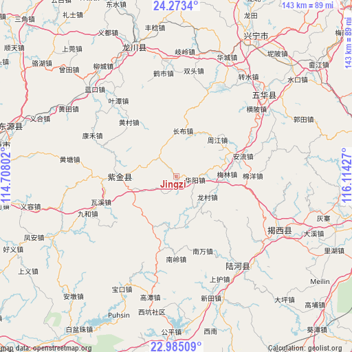
Jingzi GPS coordinates[2]
23° 37' 50.988" North, 115° 24' 40.104" East
| Map corner | latitude | longitude |
|---|---|---|
| Upper-left | 24.2734°, | 114.70802° |
| Center: | 23.63083°, | 115.41114° |
| Lower-right: | 22.98509°, | 116.11427° |
| Map W x H: | 143.2×143.2 km | = 89×89mi |
| max Lat: | 53.31946° ⇑91.6% North |
| Jingzi: | 23.63083° |
| min Lat: | ⇓8.4% South 18.22056° |
| min Long | Jingzi | max Long |
| 75.07348° | 115.41114° | 134.28917° |
| W 56.5%⇐ | ⇒43.5% E |
Elevation
Elevation of Jingzi is 232 m = 761 ft, and this is 252.8 m = 829 ft below average elevation for this country.
| Max E: |
5622 m = 18445 ft | 42.4% |
| Avg. | 484.8 m = 1591 ft | |
| Jingzi | 232 m = 761 ft | |
Min E: |
-3 m = -10 ft | 57.6% |
See also: China elevation on elevation.city.
Geographical zone
Jingzi is located in North temperate zone (between Tropic of Cancer and the Arctic Circle). Distance of this Northern Tropic circle is 21.6 km =13.4 mi to South.| Distance of | km | miles | from Jingzi |
|---|---|---|---|
| North Pole | 7379.6 | 4585.5 | to North |
| Arctic Circle | 4773.7 | 2966.2 | to North |
| Tropic Cancer | 21.6 | 13.4 | to South |
| Equator | 2627.5 | 1632.7 | to South |


Nearby cities:
15 places around Jingzi: (largest is in red/bold)
• Anliu
28.3 km =17.6 mi,  74°
74°
• Changbu
18.3 km =11.4 mi,  8°
8°
• Datian
25.6 km =15.9 mi, 8°
• Fucheng
25.4 km =15.8 mi,  273°
273°
• Huangcun
29.5 km =18.3 mi,  320°
320°
• Jiushu
30.4 km =18.9 mi,  230°
230°
• Longcun
15.2 km =9.4 mi,  125°
125°
• Longwo
20.5 km =12.7 mi,  212°
212°
• Meilin
20.6 km =12.8 mi,  87°
87°
• Mianyang
31 km =19.3 mi, 89°
• Shuidun
10.9 km =6.8 mi,  176°
176°
• Wushi
22.1 km =13.7 mi, 268°
• Zhongba
10.9 km =6.8 mi, 322°
• Zhoujiang
21.8 km =13.5 mi,  49°
49°
• Zicheng
23.9 km =14.9 mi, 274°
Sources, notices
• [Note1] Compared only with cities in China existing in our database
• [Src1] Map data: © OpenStreetMap contributors (CC-BY-SA)
• [Src2] Other city data from geonames.org with taken over terms of usage.
• [Src3] Geographical zone / Annual Mean Temperature by Robert A. Rohde @ Wikipedia
