Putian geodata
Putian (Guangdong) is a seat of a fourth-order administrative division; located in China in Asia/Shanghai (GMT+8) time zone. In our database, there are 1268 cities with bigger population. Compared to other cities in China, 91.7% of cities are located further ↑North; 62.4% of cities are located further ←West and 82.1% of cities have higher elevation than Putian. Note1


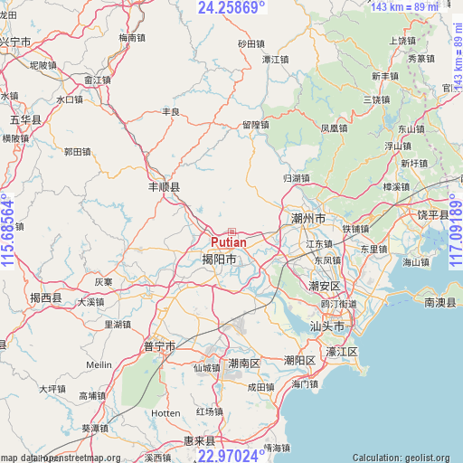
Putian GPS coordinates[2]
23° 36' 57.78" North, 116° 23' 19.536" East
| Map corner | latitude | longitude |
|---|---|---|
| Upper-left | 24.25869°, | 115.68564° |
| Center: | 23.61605°, | 116.38876° |
| Lower-right: | 22.97024°, | 117.09189° |
| Map W x H: | 143.3×143.3 km | = 89×89mi |
| max Lat: | 53.31946° ⇑91.7% North |
| Putian: | 23.61605° |
| min Lat: | ⇓8.3% South 18.22056° |
| min Long | Putian | max Long |
| 75.07348° | 116.38876° | 134.28917° |
| W 62.4%⇐ | ⇒37.6% E |
Elevation
Elevation of Putian is 22 m = 72 ft, and this is 462.8 m = 1518 ft below average elevation for this country.
| Max E: |
5622 m = 18445 ft | 82.1% |
| Avg. | 484.8 m = 1591 ft | |
| Putian | 22 m = 72 ft | |
Min E: |
-3 m = -10 ft | 17.9% |
See also: China elevation on elevation.city.
Geographical zone
Putian is located in North temperate zone (between Tropic of Cancer and the Arctic Circle). Distance of this Northern Tropic circle is 19.9 km =12.4 mi to South.| Distance of | km | miles | from Putian |
|---|---|---|---|
| North Pole | 7381.2 | 4586.5 | to North |
| Arctic Circle | 4775.3 | 2967.2 | to North |
| Tropic Cancer | 19.9 | 12.4 | to South |
| Equator | 2625.9 | 1631.7 | to South |


Nearby cities:
15 places around Putian: (largest is in red/bold)
• Denggang
15.2 km =9.4 mi,  121°
121°
• Dengtang
15.8 km =9.8 mi,  62°
62°
• Guiling
15.7 km =9.8 mi,  258°
258°
• Jieyang
8.6 km =5.3 mi,  195°
195°
• Linpan
16.9 km =10.5 mi,  246°
246°
• Meiyun
13.2 km =8.2 mi,  216°
216°
• Paotai
15.1 km =9.4 mi,  133°
133°
• Quxi
6.6 km =4.1 mi,  138°
138°
• Xianqiao
13.9 km =8.6 mi, 197°
• Xichang
6.4 km =4 mi,  266°
266°
• Xinheng
10.7 km =6.6 mi,  284°
284°
• Yuecheng
13.5 km =8.4 mi,  244°
244°
• Yuhu
17.4 km =10.8 mi,  294°
294°
• Yujiao
13 km =8.1 mi,  91°
91°
• Yunlu
9.1 km =5.7 mi,  103°
103°
Sources, notices
• [Note1] Compared only with cities in China existing in our database
• [Src1] Map data: © OpenStreetMap contributors (CC-BY-SA)
• [Src2] Other city data from geonames.org with taken over terms of usage.
• [Src3] Geographical zone / Annual Mean Temperature by Robert A. Rohde @ Wikipedia
