Xinheng geodata
Xinheng (Guangdong) is a seat of a fourth-order administrative division; located in China in Asia/Shanghai (GMT+8) time zone. In our database, there are 1268 cities with bigger population. Compared to other cities in China, 91.6% of cities are located further ↑North; 61.7% of cities are located further ←West and 86.9% of cities have higher elevation than Xinheng. Note1


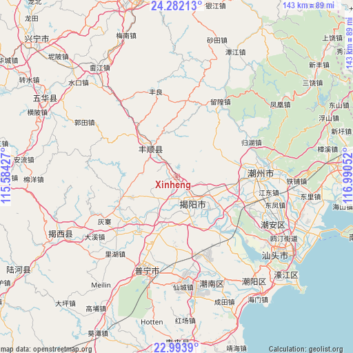
Xinheng GPS coordinates[2]
23° 38' 22.56" North, 116° 17' 14.604" East
| Map corner | latitude | longitude |
|---|---|---|
| Upper-left | 24.28213°, | 115.58427° |
| Center: | 23.6396°, | 116.28739° |
| Lower-right: | 22.9939°, | 116.99052° |
| Map W x H: | 143.2×143.2 km | = 89×89mi |
| max Lat: | 53.31946° ⇑91.6% North |
| Xinheng: | 23.6396° |
| min Lat: | ⇓8.4% South 18.22056° |
| min Long | Xinheng | max Long |
| 75.07348° | 116.28739° | 134.28917° |
| W 61.7%⇐ | ⇒38.3% E |
Elevation
Elevation of Xinheng is 13 m = 43 ft, and this is 471.8 m = 1548 ft below average elevation for this country.
| Max E: |
5622 m = 18445 ft | 86.9% |
| Avg. | 484.8 m = 1591 ft | |
| Xinheng | 13 m = 43 ft | |
Min E: |
-3 m = -10 ft | 13.1% |
See also: China elevation on elevation.city.
Geographical zone
Xinheng is located in North temperate zone (between Tropic of Cancer and the Arctic Circle). Distance of this Northern Tropic circle is 22.6 km =14 mi to South.| Distance of | km | miles | from Xinheng |
|---|---|---|---|
| North Pole | 7378.6 | 4584.8 | to North |
| Arctic Circle | 4772.7 | 2965.6 | to North |
| Tropic Cancer | 22.6 | 14 | to South |
| Equator | 2628.5 | 1633.3 | to South |


Nearby cities:
15 places around Xinheng: (largest is in red/bold)
• Baita
12.3 km =7.6 mi,  224°
224°
• Buzhai
13.8 km =8.6 mi,  274°
274°
• Guiling
7.7 km =4.8 mi, 221°
• Jieyang
13.5 km =8.4 mi,  143°
143°
• Linpan
10.8 km =6.7 mi,  208°
208°
• Longwei
15.9 km =9.9 mi,  243°
243°
• Meiyun
13.5 km =8.4 mi,  169°
169°
• Nanxi
15.6 km =9.7 mi,  198°
198°
• Putian
10.7 km =6.6 mi,  104°
104°
• Quxi
16.5 km =10.3 mi,  117°
117°
• Tangnan
12.9 km =8 mi,  316°
316°
• Xianqiao
17 km =10.6 mi,  158°
158°
• Xichang
5 km =3.1 mi,  126°
126°
• Yuecheng
8.7 km =5.4 mi,  192°
192°
• Yuhu
7.2 km =4.5 mi,  310°
310°
Sources, notices
• [Note1] Compared only with cities in China existing in our database
• [Src1] Map data: © OpenStreetMap contributors (CC-BY-SA)
• [Src2] Other city data from geonames.org with taken over terms of usage.
• [Src3] Geographical zone / Annual Mean Temperature by Robert A. Rohde @ Wikipedia
