Bailai geodata
Bailai (Fujian) is a seat of a fourth-order administrative division; located in China in Asia/Shanghai (GMT+8) time zone. In our database, there are 1268 cities with bigger population. Compared to other cities in China, 85.2% of cities are located further ↑North; 70.7% of cities are located further ←West and 51.2% of cities have higher elevation than Bailai. Note1


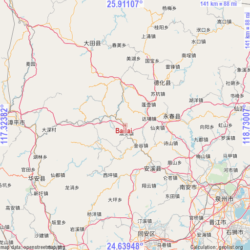
Bailai GPS coordinates[2]
25° 16' 36.984" North, 118° 1' 36.984" East
| Map corner | latitude | longitude |
|---|---|---|
| Upper-left | 25.91107°, | 117.32382° |
| Center: | 25.27694°, | 118.02694° |
| Lower-right: | 24.63948°, | 118.73007° |
| Map W x H: | 141.4×141.4 km | = 87.9×87.9mi |
| max Lat: | 53.31946° ⇑85.2% North |
| Bailai: | 25.27694° |
| min Lat: | ⇓14.8% South 18.22056° |
| min Long | Bailai | max Long |
| 75.07348° | 118.02694° | 134.28917° |
| W 70.7%⇐ | ⇒29.3% E |
Elevation
Elevation of Bailai is 155 m = 509 ft, and this is 329.8 m = 1082 ft below average elevation for this country.
| Max E: |
5622 m = 18445 ft | 51.2% |
| Avg. | 484.8 m = 1591 ft | |
| Bailai | 155 m = 509 ft | |
Min E: |
-3 m = -10 ft | 48.8% |
See also: China elevation on elevation.city.
Geographical zone
Bailai is located in North temperate zone (between Tropic of Cancer and the Arctic Circle). Distance of this Northern Tropic circle is 204.6 km =127.1 mi to South.| Distance of | km | miles | from Bailai |
|---|---|---|---|
| North Pole | 7196.5 | 4471.7 | to North |
| Arctic Circle | 4590.6 | 2852.5 | to North |
| Tropic Cancer | 204.6 | 127.1 | to South |
| Equator | 2810.5 | 1746.4 | to South |


Nearby cities:
15 places around Bailai: (largest is in red/bold)
• Changkeng
18.4 km =11.4 mi,  240°
240°
• Dabu
14.2 km =8.8 mi,  74°
74°
• Gande
18.1 km =11.2 mi,  277°
277°
• Hushang
7.3 km =4.5 mi, 242°
• Hutou
5.7 km =3.5 mi,  157°
157°
• Jiandou
11.1 km =6.9 mi,  297°
297°
• Jindou
18.8 km =11.7 mi,  23°
23°
• Jingu
14.7 km =9.1 mi,  142°
142°
• Kengzikou
16.2 km =10.1 mi,  356°
356°
• Penghu
17.2 km =10.7 mi,  46°
46°
• Penghua
19.1 km =11.9 mi,  118°
118°
• Penglai
17.3 km =10.7 mi, 158°
• Shangqing
19.6 km =12.2 mi,  198°
198°
• Xianjia
18.8 km =11.7 mi,  94°
94°
• Yudou
12.9 km =8 mi,  4°
4°
Sources, notices
• [Note1] Compared only with cities in China existing in our database
• [Src1] Map data: © OpenStreetMap contributors (CC-BY-SA)
• [Src2] Other city data from geonames.org with taken over terms of usage.
• [Src3] Geographical zone / Annual Mean Temperature by Robert A. Rohde @ Wikipedia
