Hutou geodata
Hutou (Fujian) is a seat of a fourth-order administrative division; located in China in Asia/Shanghai (GMT+8) time zone. In our database, there are 1268 cities with bigger population. Compared to other cities in China, 85.4% of cities are located further ↑North; 70.8% of cities are located further ←West and 60.1% of cities have higher elevation than Hutou. Note1


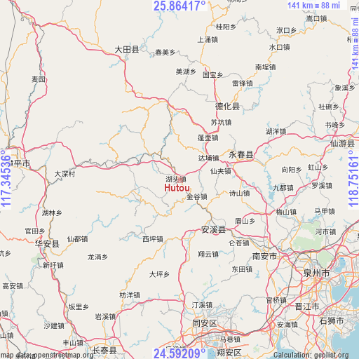
Hutou GPS coordinates[2]
25° 13' 47.244" North, 118° 2' 54.528" East
| Map corner | latitude | longitude |
|---|---|---|
| Upper-left | 25.86417°, | 117.34536° |
| Center: | 25.22979°, | 118.04848° |
| Lower-right: | 24.59209°, | 118.75161° |
| Map W x H: | 141.4×141.4 km | = 87.9×87.9mi |
| max Lat: | 53.31946° ⇑85.4% North |
| Hutou: | 25.22979° |
| min Lat: | ⇓14.6% South 18.22056° |
| min Long | Hutou | max Long |
| 75.07348° | 118.04848° | 134.28917° |
| W 70.8%⇐ | ⇒29.2% E |
Elevation
Elevation of Hutou is 98 m = 322 ft, and this is 386.8 m = 1269 ft below average elevation for this country.
| Max E: |
5622 m = 18445 ft | 60.1% |
| Avg. | 484.8 m = 1591 ft | |
| Hutou | 98 m = 322 ft | |
Min E: |
-3 m = -10 ft | 39.9% |
See also: China elevation on elevation.city.
Geographical zone
Hutou is located in North temperate zone (between Tropic of Cancer and the Arctic Circle). Distance of this Northern Tropic circle is 199.4 km =123.9 mi to South.| Distance of | km | miles | from Hutou |
|---|---|---|---|
| North Pole | 7201.8 | 4475 | to North |
| Arctic Circle | 4595.9 | 2855.8 | to North |
| Tropic Cancer | 199.4 | 123.9 | to South |
| Equator | 2805.3 | 1743.1 | to South |


Nearby cities:
15 places around Hutou: (largest is in red/bold)
• Bailai
5.7 km =3.5 mi,  337°
337°
• Changkeng
18.6 km =11.6 mi,  258°
258°
• Dabu
14.7 km =9.1 mi,  51°
51°
• Gande
21.6 km =13.4 mi,  290°
290°
• Hushang
8.8 km =5.5 mi,  282°
282°
• Jiandou
15.8 km =9.8 mi,  310°
310°
• Jingu
9.3 km =5.8 mi,  133°
133°
• Kuidou
15.1 km =9.4 mi, 134°
• Lantian
20.5 km =12.7 mi,  238°
238°
• Penghu
20 km =12.4 mi,  31°
31°
• Penghua
15.2 km =9.4 mi,  104°
104°
• Penglai
11.7 km =7.3 mi,  158°
158°
• Shangqing
15.8 km =9.8 mi,  212°
212°
• Xianjia
17 km =10.6 mi,  77°
77°
• Yudou
18.2 km =11.3 mi,  356°
356°
Sources, notices
• [Note1] Compared only with cities in China existing in our database
• [Src1] Map data: © OpenStreetMap contributors (CC-BY-SA)
• [Src2] Other city data from geonames.org with taken over terms of usage.
• [Src3] Geographical zone / Annual Mean Temperature by Robert A. Rohde @ Wikipedia
