Xianjia geodata
Xianjia (Fujian) is a seat of a fourth-order administrative division; located in China in Asia/Shanghai (GMT+8) time zone. In our database, there are 1268 cities with bigger population. Compared to other cities in China, 85.3% of cities are located further ↑North; 71.5% of cities are located further ←West and 76.1% of cities have lower elevation than Xianjia. Note1


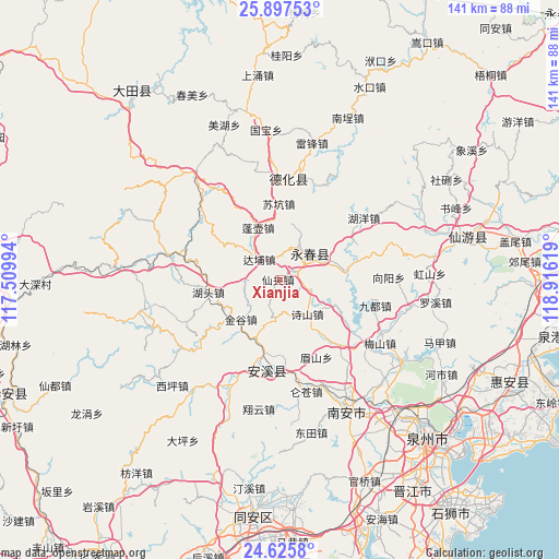
Xianjia GPS coordinates[2]
25° 15' 47.988" North, 118° 12' 47.016" East
| Map corner | latitude | longitude |
|---|---|---|
| Upper-left | 25.89753°, | 117.50994° |
| Center: | 25.26333°, | 118.21306° |
| Lower-right: | 24.6258°, | 118.91619° |
| Map W x H: | 141.4×141.4 km | = 87.9×87.9mi |
| max Lat: | 53.31946° ⇑85.3% North |
| Xianjia: | 25.26333° |
| min Lat: | ⇓14.7% South 18.22056° |
| min Long | Xianjia | max Long |
| 75.07348° | 118.21306° | 134.28917° |
| W 71.5%⇐ | ⇒28.5% E |
Elevation
Elevation of Xianjia is 548 m = 1798 ft, and this is 63.2 m = 207 ft above average elevation for this country.
| Max E: |
5622 m = 18445 ft | 23.9% |
| Xianjia | 548 m 1798 ft | |
| Avg. | 484.8 m = 1591 ft | |
Min E: |
-3 m = -10 ft | 76.1% |
See also: China elevation on elevation.city.
Geographical zone
Xianjia is located in North temperate zone (between Tropic of Cancer and the Arctic Circle). Distance of this Northern Tropic circle is 203.1 km =126.2 mi to South.| Distance of | km | miles | from Xianjia |
|---|---|---|---|
| North Pole | 7198 | 4472.6 | to North |
| Arctic Circle | 4592.2 | 2853.5 | to North |
| Tropic Cancer | 203.1 | 126.2 | to South |
| Equator | 2809 | 1745.4 | to South |


Nearby cities:
15 places around Xianjia: (largest is in red/bold)
• Bailai
18.8 km =11.7 mi,  274°
274°
• Dabu
7.3 km =4.5 mi,  316°
316°
• Dongguan
15.1 km =9.4 mi,  76°
76°
• Dongping
13 km =8.1 mi,  68°
68°
• Hutou
17 km =10.6 mi,  257°
257°
• Jingu
14.1 km =8.8 mi,  224°
224°
• Kuidou
15.6 km =9.7 mi,  202°
202°
• Matou
17 km =10.6 mi,  117°
117°
• Penghu
14.7 km =9.1 mi,  335°
335°
• Penghua
7.8 km =4.8 mi,  194°
194°
• Penglai
19 km =11.8 mi, 220°
• Shigu
9.1 km =5.7 mi,  22°
22°
• Taocheng
10.3 km =6.4 mi,  58°
58°
• Wufeng
14.6 km =9.1 mi,  10°
10°
• Wulijie
9.5 km =5.9 mi,  37°
37°
Sources, notices
• [Note1] Compared only with cities in China existing in our database
• [Src1] Map data: © OpenStreetMap contributors (CC-BY-SA)
• [Src2] Other city data from geonames.org with taken over terms of usage.
• [Src3] Geographical zone / Annual Mean Temperature by Robert A. Rohde @ Wikipedia
