Dongping geodata
Dongping (Fujian) is a seat of a fourth-order administrative division; located in China in Asia/Shanghai (GMT+8) time zone. In our database, there are 1268 cities with bigger population. Compared to other cities in China, 85.1% of cities are located further ↑North; 72.2% of cities are located further ←West and 56.6% of cities have higher elevation than Dongping. Note1


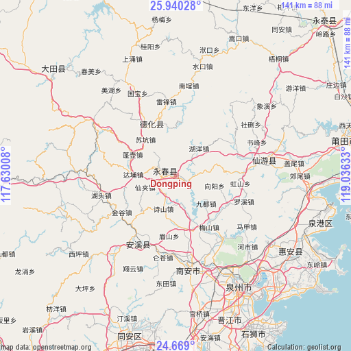
Dongping GPS coordinates[2]
25° 18' 22.716" North, 118° 19' 59.52" East
| Map corner | latitude | longitude |
|---|---|---|
| Upper-left | 25.94028°, | 117.63008° |
| Center: | 25.30631°, | 118.3332° |
| Lower-right: | 24.669°, | 119.03633° |
| Map W x H: | 141.4×141.4 km | = 87.9×87.9mi |
| max Lat: | 53.31946° ⇑85.1% North |
| Dongping: | 25.30631° |
| min Lat: | ⇓14.9% South 18.22056° |
| min Long | Dongping | max Long |
| 75.07348° | 118.3332° | 134.28917° |
| W 72.2%⇐ | ⇒27.8% E |
Elevation
Elevation of Dongping is 120 m = 394 ft, and this is 364.8 m = 1197 ft below average elevation for this country.
| Max E: |
5622 m = 18445 ft | 56.6% |
| Avg. | 484.8 m = 1591 ft | |
| Dongping | 120 m = 394 ft | |
Min E: |
-3 m = -10 ft | 43.4% |
See also: China elevation on elevation.city.
Geographical zone
Dongping is located in North temperate zone (between Tropic of Cancer and the Arctic Circle). Distance of this Northern Tropic circle is 207.9 km =129.2 mi to South.| Distance of | km | miles | from Dongping |
|---|---|---|---|
| North Pole | 7193.3 | 4469.7 | to North |
| Arctic Circle | 4587.4 | 2850.5 | to North |
| Tropic Cancer | 207.9 | 129.2 | to South |
| Equator | 2813.8 | 1748.4 | to South |


Nearby cities:
15 places around Dongping: (largest is in red/bold)
• Dabu
17.1 km =10.6 mi,  271°
271°
• Dongguan
2.9 km =1.8 mi,  116°
116°
• Huyang
14.3 km =8.9 mi,  39°
39°
• Jiefu
14 km =8.7 mi,  350°
350°
• Jiudu
16.6 km =10.3 mi,  132°
132°
• Matou
13 km =8.1 mi,  166°
166°
• Penghua
18.7 km =11.6 mi,  228°
228°
• Sanban
16.7 km =10.4 mi,  344°
344°
• Shigu
9.4 km =5.8 mi,  292°
292°
• Sukeng
18.6 km =11.6 mi,  320°
320°
• Taocheng
3.3 km =2.1 mi,  281°
281°
• Waishan
14.1 km =8.8 mi,  83°
83°
• Wufeng
13.4 km =8.3 mi, 315°
• Wulijie
6.8 km =4.2 mi, 293°
• Xianjia
13 km =8.1 mi,  248°
248°
Sources, notices
• [Note1] Compared only with cities in China existing in our database
• [Src1] Map data: © OpenStreetMap contributors (CC-BY-SA)
• [Src2] Other city data from geonames.org with taken over terms of usage.
• [Src3] Geographical zone / Annual Mean Temperature by Robert A. Rohde @ Wikipedia
