Qinyang geodata
Qinyang (Fujian) is a seat of a fourth-order administrative division; located in China in Asia/Shanghai (GMT+8) time zone. In our database, there are 1268 cities with bigger population. Compared to other cities in China, 77.1% of cities are located further ↑North; 78.1% of cities are located further ←West and 72.1% of cities have lower elevation than Qinyang. Note1


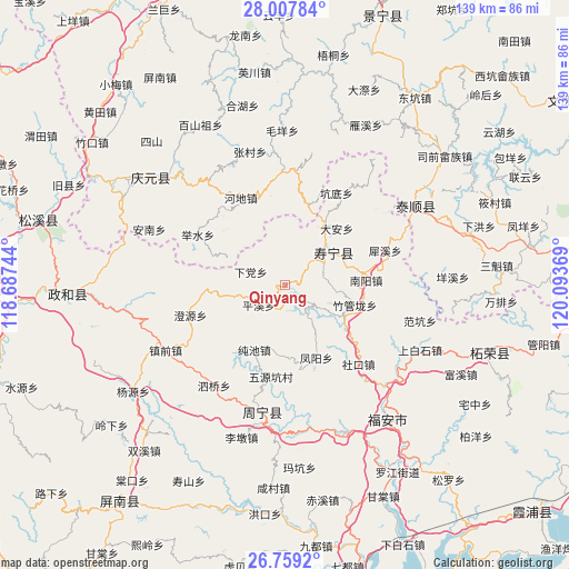
Qinyang GPS coordinates[2]
27° 23' 7.008" North, 119° 23' 26.016" East
| Map corner | latitude | longitude |
|---|---|---|
| Upper-left | 28.00784°, | 118.68744° |
| Center: | 27.38528°, | 119.39056° |
| Lower-right: | 26.7592°, | 120.09369° |
| Map W x H: | 138.8×138.8 km | = 86.2×86.2mi |
| max Lat: | 53.31946° ⇑77.1% North |
| Qinyang: | 27.38528° |
| min Lat: | ⇓22.9% South 18.22056° |
| min Long | Qinyang | max Long |
| 75.07348° | 119.39056° | 134.28917° |
| W 78.1%⇐ | ⇒21.9% E |
Elevation
Elevation of Qinyang is 455 m = 1493 ft, and this is 29.8 m = 98 ft below average elevation for this country.
| Max E: |
5622 m = 18445 ft | 27.9% |
| Avg. | 484.8 m = 1591 ft | |
| Qinyang | 455 m = 1493 ft | |
Min E: |
-3 m = -10 ft | 72.1% |
See also: China elevation on elevation.city.
Geographical zone
Qinyang is located in North temperate zone (between Tropic of Cancer and the Arctic Circle). Distance of this Northern Tropic circle is 439 km =272.8 mi to South.| Distance of | km | miles | from Qinyang |
|---|---|---|---|
| North Pole | 6962.1 | 4326 | to North |
| Arctic Circle | 4356.2 | 2706.8 | to North |
| Tropic Cancer | 439 | 272.8 | to South |
| Equator | 3045 | 1892.1 | to South |


Nearby cities:
15 places around Qinyang: (largest is in red/bold)
• Aoyang
13.7 km =8.5 mi,  53°
53°
• Chunchi
17.5 km =10.9 mi,  205°
205°
• Da’an
18.8 km =11.7 mi,  42°
42°
• Fengyang
19.3 km =12 mi,  156°
156°
• Jianggen
19.7 km =12.2 mi,  13°
13°
• Lingtou
23.4 km =14.5 mi,  322°
322°
• Longxi
16.2 km =10.1 mi,  296°
296°
• Nanyang
19.6 km =12.2 mi,  87°
87°
• Pingxi
8.2 km =5.1 mi,  234°
234°
• Qingyuan
10 km =6.2 mi,  79°
79°
• Tuoxi
7 km =4.3 mi,  338°
338°
• Xiadang
8.8 km =5.5 mi,  286°
286°
• Xiaoyang
22.8 km =14.2 mi, 164°
• Xietan
15.5 km =9.6 mi,  116°
116°
• Zhuguanlong
17.8 km =11.1 mi,  105°
105°
Sources, notices
• [Note1] Compared only with cities in China existing in our database
• [Src1] Map data: © OpenStreetMap contributors (CC-BY-SA)
• [Src2] Other city data from geonames.org with taken over terms of usage.
• [Src3] Geographical zone / Annual Mean Temperature by Robert A. Rohde @ Wikipedia
