Pingxi geodata
Pingxi (Fujian) is a seat of a fourth-order administrative division; located in China in Asia/Shanghai (GMT+8) time zone. In our database, there are 1268 cities with bigger population. Compared to other cities in China, 77.2% of cities are located further ↑North; 77.8% of cities are located further ←West and 77.4% of cities have lower elevation than Pingxi. Note1


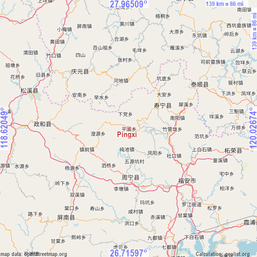
Pingxi GPS coordinates[2]
27° 20' 32.244" North, 119° 19' 24.996" East
| Map corner | latitude | longitude |
|---|---|---|
| Upper-left | 27.96509°, | 118.62049° |
| Center: | 27.34229°, | 119.32361° |
| Lower-right: | 26.71597°, | 120.02674° |
| Map W x H: | 138.9×138.9 km | = 86.3×86.3mi |
| max Lat: | 53.31946° ⇑77.2% North |
| Pingxi: | 27.34229° |
| min Lat: | ⇓22.8% South 18.22056° |
| min Long | Pingxi | max Long |
| 75.07348° | 119.32361° | 134.28917° |
| W 77.8%⇐ | ⇒22.2% E |
Elevation
Elevation of Pingxi is 587 m = 1926 ft, and this is 102.2 m = 335 ft above average elevation for this country.
| Max E: |
5622 m = 18445 ft | 22.6% |
| Pingxi | 587 m 1926 ft | |
| Avg. | 484.8 m = 1591 ft | |
Min E: |
-3 m = -10 ft | 77.4% |
See also: China elevation on elevation.city.
Geographical zone
Pingxi is located in North temperate zone (between Tropic of Cancer and the Arctic Circle). Distance of this Northern Tropic circle is 434.3 km =269.9 mi to South.| Distance of | km | miles | from Pingxi |
|---|---|---|---|
| North Pole | 6966.9 | 4329 | to North |
| Arctic Circle | 4361 | 2709.8 | to North |
| Tropic Cancer | 434.3 | 269.9 | to South |
| Equator | 3040.2 | 1889.1 | to South |


Nearby cities:
15 places around Pingxi: (largest is in red/bold)
• Aoyang
21.8 km =13.5 mi,  53°
53°
• Chengyuan
16.8 km =10.4 mi,  261°
261°
• Chunchi
11 km =6.8 mi,  185°
185°
• Fengyang
19.2 km =11.9 mi,  132°
132°
• Jushui
22.6 km =14 mi,  319°
319°
• Longxi
14.3 km =8.9 mi,  326°
326°
• Puyuan
24.5 km =15.2 mi, 186°
• Qingyuan
17.7 km =11 mi,  68°
68°
• Qinyang
8.2 km =5.1 mi, 54°
• Siqiao
22.5 km =14 mi,  208°
208°
• Tuoxi
12 km =7.5 mi,  19°
19°
• Xiadang
7.6 km =4.7 mi,  345°
345°
• Xiaoyang
21.3 km =13.2 mi,  143°
143°
• Xietan
20.6 km =12.8 mi,  95°
95°
• Zhuguanlong
23.7 km =14.7 mi,  90°
90°
Sources, notices
• [Note1] Compared only with cities in China existing in our database
• [Src1] Map data: © OpenStreetMap contributors (CC-BY-SA)
• [Src2] Other city data from geonames.org with taken over terms of usage.
• [Src3] Geographical zone / Annual Mean Temperature by Robert A. Rohde @ Wikipedia
