Helong geodata
Helong (Fujian) is a seat of a fourth-order administrative division; located in China in Asia/Shanghai (GMT+8) time zone. In our database, there are 1268 cities with bigger population. Compared to other cities in China, 80.6% of cities are located further ↑North; 64% of cities are located further ←West and 77.4% of cities have lower elevation than Helong. Note1


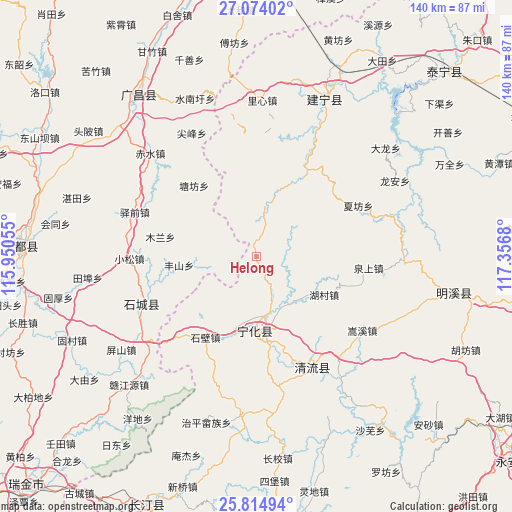
Helong GPS coordinates[2]
26° 26' 46.32" North, 116° 39' 13.212" East
| Map corner | latitude | longitude |
|---|---|---|
| Upper-left | 27.07402°, | 115.95055° |
| Center: | 26.4462°, | 116.65367° |
| Lower-right: | 25.81494°, | 117.3568° |
| Map W x H: | 140×140 km | = 87×87mi |
| max Lat: | 53.31946° ⇑80.6% North |
| Helong: | 26.4462° |
| min Lat: | ⇓19.4% South 18.22056° |
| min Long | Helong | max Long |
| 75.07348° | 116.65367° | 134.28917° |
| W 64%⇐ | ⇒36% E |
Elevation
Elevation of Helong is 589 m = 1932 ft, and this is 104.2 m = 342 ft above average elevation for this country.
| Max E: |
5622 m = 18445 ft | 22.6% |
| Helong | 589 m 1932 ft | |
| Avg. | 484.8 m = 1591 ft | |
Min E: |
-3 m = -10 ft | 77.4% |
See also: China elevation on elevation.city.
Geographical zone
Helong is located in North temperate zone (between Tropic of Cancer and the Arctic Circle). Distance of this Northern Tropic circle is 334.6 km =207.9 mi to South.| Distance of | km | miles | from Helong |
|---|---|---|---|
| North Pole | 7066.5 | 4390.9 | to North |
| Arctic Circle | 4460.6 | 2771.7 | to North |
| Tropic Cancer | 334.6 | 207.9 | to South |
| Equator | 2940.5 | 1827.1 | to South |


Nearby cities:
15 places around Helong: (largest is in red/bold)
• Anyuan
14.7 km =9.1 mi,  8°
8°
• Chengnan
26.3 km =16.3 mi,  166°
166°
• Cuijiang
20.4 km =12.7 mi,  181°
181°
• Dushang
28.8 km =17.9 mi,  20°
20°
• Fengshan
21.3 km =13.2 mi,  264°
264°
• Fengxi
20.9 km =13 mi,  69°
69°
• Gaotian
18.5 km =11.5 mi,  278°
278°
• Hucun
21.9 km =13.6 mi,  119°
119°
• Junkou
27.4 km =17 mi,  30°
30°
• Mulan
26.8 km =16.7 mi, 281°
• Shuiqian
9.2 km =5.7 mi,  75°
75°
• Tangfang
25.9 km =16.1 mi,  318°
318°
• Xianan
20 km =12.4 mi, 178°
• Xinji
15.5 km =9.6 mi,  219°
219°
• Xinshi
26 km =16.2 mi,  212°
212°
Sources, notices
• [Note1] Compared only with cities in China existing in our database
• [Src1] Map data: © OpenStreetMap contributors (CC-BY-SA)
• [Src2] Other city data from geonames.org with taken over terms of usage.
• [Src3] Geographical zone / Annual Mean Temperature by Robert A. Rohde @ Wikipedia
