Wudang geodata
Wudang (Jiangxi) is a seat of a fourth-order administrative division; located in China in Asia/Shanghai (GMT+8) time zone. In our database, there are 1268 cities with bigger population. Compared to other cities in China, 87.9% of cities are located further ↑North; 52.9% of cities are located further ←West and 68.3% of cities have lower elevation than Wudang. Note1


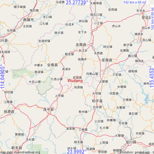
Wudang GPS coordinates[2]
24° 38' 23.748" North, 114° 45' 7.812" East
| Map corner | latitude | longitude |
|---|---|---|
| Upper-left | 25.27739°, | 114.04905° |
| Center: | 24.63993°, | 114.75217° |
| Lower-right: | 23.9992°, | 115.4553° |
| Map W x H: | 142.1×142.1 km | = 88.3×88.3mi |
| max Lat: | 53.31946° ⇑87.9% North |
| Wudang: | 24.63993° |
| min Lat: | ⇓12.1% South 18.22056° |
| min Long | Wudang | max Long |
| 75.07348° | 114.75217° | 134.28917° |
| W 52.9%⇐ | ⇒47.1% E |
Elevation
Elevation of Wudang is 382 m = 1253 ft, and this is 102.8 m = 337 ft below average elevation for this country.
| Max E: |
5622 m = 18445 ft | 31.7% |
| Avg. | 484.8 m = 1591 ft | |
| Wudang | 382 m = 1253 ft | |
Min E: |
-3 m = -10 ft | 68.3% |
See also: China elevation on elevation.city.
Geographical zone
Wudang is located in North temperate zone (between Tropic of Cancer and the Arctic Circle). Distance of this Northern Tropic circle is 133.8 km =83.1 mi to South.| Distance of | km | miles | from Wudang |
|---|---|---|---|
| North Pole | 7267.4 | 4515.8 | to North |
| Arctic Circle | 4661.5 | 2896.5 | to North |
| Tropic Cancer | 133.8 | 83.1 | to South |
| Equator | 2739.7 | 1702.4 | to South |


Nearby cities:
15 places around Wudang: (largest is in red/bold)
• Chenglong
22.8 km =14.2 mi,  340°
340°
• Daba
23.7 km =14.7 mi,  128°
128°
• Dujiang
25.8 km =16 mi,  348°
348°
• Jiahu
12.7 km =7.9 mi,  307°
307°
• Jinlong
25.3 km =15.7 mi,  299°
299°
• Kuimeishan
14.1 km =8.8 mi,  76°
76°
• Laocheng
24.5 km =15.2 mi, 77°
• Lintang
17.4 km =10.8 mi,  15°
15°
• Liyuan
9.1 km =5.7 mi,  174°
174°
• Nanheng
8.3 km =5.2 mi,  33°
33°
• Reshui
22.1 km =13.7 mi,  159°
159°
• Shangling
24.4 km =15.2 mi,  100°
100°
• Shangping
23.4 km =14.5 mi,  220°
220°
• Wenlong
20.5 km =12.7 mi,  46°
46°
• Yangcun
12.6 km =7.8 mi,  268°
268°
Sources, notices
• [Note1] Compared only with cities in China existing in our database
• [Src1] Map data: © OpenStreetMap contributors (CC-BY-SA)
• [Src2] Other city data from geonames.org with taken over terms of usage.
• [Src3] Geographical zone / Annual Mean Temperature by Robert A. Rohde @ Wikipedia
