Daba geodata
Daba (Guangdong) is a seat of a fourth-order administrative division; located in China in Asia/Shanghai (GMT+8) time zone. In our database, there are 1268 cities with bigger population. Compared to other cities in China, 88.4% of cities are located further ↑North; 53.9% of cities are located further ←West and 56.4% of cities have lower elevation than Daba. Note1


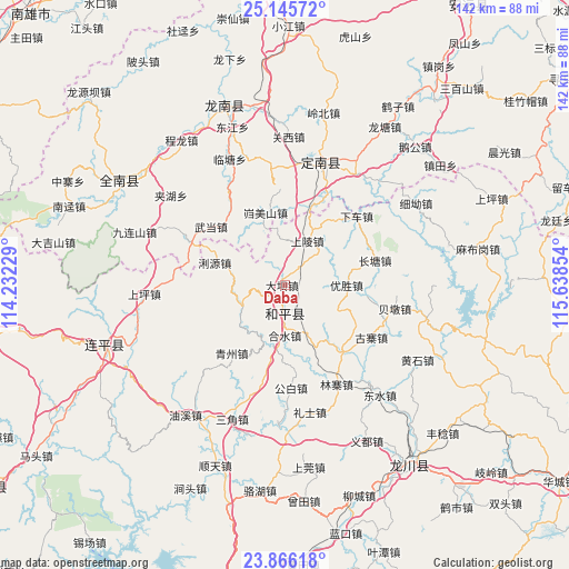
Daba GPS coordinates[2]
24° 30' 27.288" North, 114° 56' 7.476" East
| Map corner | latitude | longitude |
|---|---|---|
| Upper-left | 25.14572°, | 114.23229° |
| Center: | 24.50758°, | 114.93541° |
| Lower-right: | 23.86618°, | 115.63854° |
| Map W x H: | 142.3×142.3 km | = 88.4×88.4mi |
| max Lat: | 53.31946° ⇑88.4% North |
| Daba: | 24.50758° |
| min Lat: | ⇓11.6% South 18.22056° |
| min Long | Daba | max Long |
| 75.07348° | 114.93541° | 134.28917° |
| W 53.9%⇐ | ⇒46.1% E |
Elevation
Elevation of Daba is 220 m = 722 ft, and this is 264.8 m = 869 ft below average elevation for this country.
| Max E: |
5622 m = 18445 ft | 43.6% |
| Avg. | 484.8 m = 1591 ft | |
| Daba | 220 m = 722 ft | |
Min E: |
-3 m = -10 ft | 56.4% |
See also: China elevation on elevation.city.
Geographical zone
Daba is located in North temperate zone (between Tropic of Cancer and the Arctic Circle). Distance of this Northern Tropic circle is 119.1 km =74 mi to South.| Distance of | km | miles | from Daba |
|---|---|---|---|
| North Pole | 7282.1 | 4524.9 | to North |
| Arctic Circle | 4676.2 | 2905.7 | to North |
| Tropic Cancer | 119.1 | 74 | to South |
| Equator | 2725 | 1693.2 | to South |


Nearby cities:
15 places around Daba: (largest is in red/bold)
• Changtang
22 km =13.7 mi,  75°
75°
• Gongbai
25.5 km =15.8 mi,  175°
175°
• Guzhai
25.2 km =15.7 mi,  121°
121°
• Heshui
12.5 km =7.8 mi, 180°
• Kuimeishan
18.6 km =11.6 mi,  344°
344°
• Laocheng
20.8 km =12.9 mi,  15°
15°
• Liyuan
18.5 km =11.5 mi,  287°
287°
• Pengzhai
21.7 km =13.5 mi,  137°
137°
• Qingzhou
21.6 km =13.4 mi,  218°
218°
• Reshui
12.4 km =7.7 mi,  241°
241°
• Shangling
11.8 km =7.3 mi,  27°
27°
• Wudang
23.7 km =14.7 mi,  308°
308°
• Xiache
24.3 km =15.1 mi,  48°
48°
• Yangming
6 km =3.7 mi, 180°
• Yousheng
15.3 km =9.5 mi,  89°
89°
Sources, notices
• [Note1] Compared only with cities in China existing in our database
• [Src1] Map data: © OpenStreetMap contributors (CC-BY-SA)
• [Src2] Other city data from geonames.org with taken over terms of usage.
• [Src3] Geographical zone / Annual Mean Temperature by Robert A. Rohde @ Wikipedia
