Gangdong geodata
Gangdong (Jiangxi) is a seat of a fourth-order administrative division; located in China in Asia/Shanghai (GMT+8) time zone. In our database, there are 1268 cities with bigger population. Compared to other cities in China, 73.2% of cities are located further ↑North; 69.3% of cities are located further ←West and 55.7% of cities have higher elevation than Gangdong. Note1


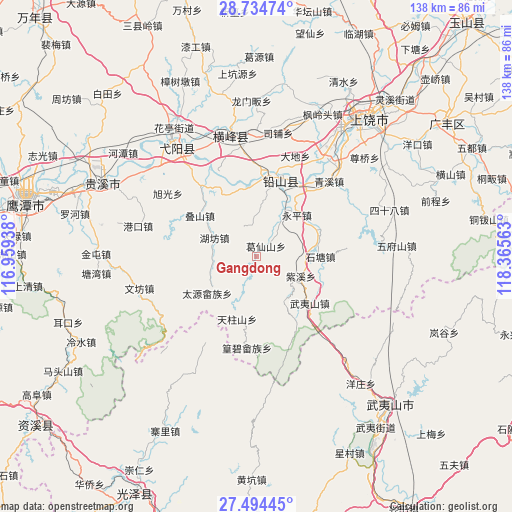
Gangdong GPS coordinates[2]
28° 6' 59.004" North, 117° 39' 45" East
| Map corner | latitude | longitude |
|---|---|---|
| Upper-left | 28.73474°, | 116.95938° |
| Center: | 28.11639°, | 117.6625° |
| Lower-right: | 27.49445°, | 118.36563° |
| Map W x H: | 137.9×137.9 km | = 85.7×85.7mi |
| max Lat: | 53.31946° ⇑73.2% North |
| Gangdong: | 28.11639° |
| min Lat: | ⇓26.8% South 18.22056° |
| min Long | Gangdong | max Long |
| 75.07348° | 117.6625° | 134.28917° |
| W 69.3%⇐ | ⇒30.7% E |
Elevation
Elevation of Gangdong is 126 m = 413 ft, and this is 358.8 m = 1177 ft below average elevation for this country.
| Max E: |
5622 m = 18445 ft | 55.7% |
| Avg. | 484.8 m = 1591 ft | |
| Gangdong | 126 m = 413 ft | |
Min E: |
-3 m = -10 ft | 44.3% |
See also: China elevation on elevation.city.
Geographical zone
Gangdong is located in North temperate zone (between Tropic of Cancer and the Arctic Circle). Distance of this Northern Tropic circle is 520.3 km =323.3 mi to South.| Distance of | km | miles | from Gangdong |
|---|---|---|---|
| North Pole | 6880.8 | 4275.5 | to North |
| Arctic Circle | 4274.9 | 2656.3 | to North |
| Tropic Cancer | 520.3 | 323.3 | to South |
| Equator | 3126.2 | 1942.5 | to South |


Nearby cities:
15 places around Gangdong: (largest is in red/bold)
• Chenfang
13.9 km =8.6 mi,  239°
239°
• Dieshan
18.6 km =11.6 mi,  305°
305°
• Ehu
23.3 km =14.5 mi,  33°
33°
• Hekou
22.6 km =14 mi,  11°
11°
• Hongqiao
14.9 km =9.3 mi, 8°
• Huanggangshan
14.1 km =8.8 mi,  146°
146°
• Hufang
12.1 km =7.5 mi,  294°
294°
• Jiaxuan
17.8 km =11.1 mi,  63°
63°
• Shitang
17.9 km =11.1 mi,  90°
90°
• Taiyuan
19.3 km =12 mi,  231°
231°
• Wuyishan
19.2 km =11.9 mi,  130°
130°
• Xin’anbu
18 km =11.2 mi,  338°
338°
• Yanglin
4 km =2.5 mi,  46°
46°
• Yongping
15.8 km =9.8 mi, 45°
• Zixi
13 km =8.1 mi,  113°
113°
Sources, notices
• [Note1] Compared only with cities in China existing in our database
• [Src1] Map data: © OpenStreetMap contributors (CC-BY-SA)
• [Src2] Other city data from geonames.org with taken over terms of usage.
• [Src3] Geographical zone / Annual Mean Temperature by Robert A. Rohde @ Wikipedia
