Dieshan geodata
Dieshan (Jiangxi) is a seat of a fourth-order administrative division; located in China in Asia/Shanghai (GMT+8) time zone. In our database, there are 1268 cities with bigger population. Compared to other cities in China, 72.3% of cities are located further ↑North; 68.8% of cities are located further ←West and 67.6% of cities have higher elevation than Dieshan. Note1


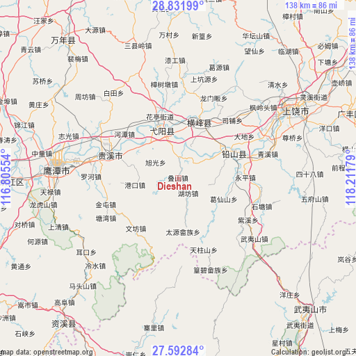
Dieshan GPS coordinates[2]
28° 12' 51.156" North, 117° 30' 31.176" East
| Map corner | latitude | longitude |
|---|---|---|
| Upper-left | 28.83199°, | 116.80554° |
| Center: | 28.21421°, | 117.50866° |
| Lower-right: | 27.59284°, | 118.21179° |
| Map W x H: | 137.8×137.8 km | = 85.6×85.6mi |
| max Lat: | 53.31946° ⇑72.3% North |
| Dieshan: | 28.21421° |
| min Lat: | ⇓27.7% South 18.22056° |
| min Long | Dieshan | max Long |
| 75.07348° | 117.50866° | 134.28917° |
| W 68.8%⇐ | ⇒31.2% E |
Elevation
Elevation of Dieshan is 62 m = 203 ft, and this is 422.8 m = 1387 ft below average elevation for this country.
| Max E: |
5622 m = 18445 ft | 67.6% |
| Avg. | 484.8 m = 1591 ft | |
| Dieshan | 62 m = 203 ft | |
Min E: |
-3 m = -10 ft | 32.4% |
See also: China elevation on elevation.city.
Geographical zone
Dieshan is located in North temperate zone (between Tropic of Cancer and the Arctic Circle). Distance of this Northern Tropic circle is 531.2 km =330.1 mi to South.| Distance of | km | miles | from Dieshan |
|---|---|---|---|
| North Pole | 6869.9 | 4268.8 | to North |
| Arctic Circle | 4264 | 2649.5 | to North |
| Tropic Cancer | 531.2 | 330.1 | to South |
| Equator | 3137.1 | 1949.3 | to South |


Nearby cities:
15 places around Dieshan: (largest is in red/bold)
• Chenfang
18.3 km =11.4 mi,  170°
170°
• Gangdong
18.6 km =11.6 mi,  125°
125°
• Gangkou
16.8 km =10.4 mi,  260°
260°
• Guifeng
18.1 km =11.2 mi,  313°
313°
• Hongqiao
17.6 km =10.9 mi,  77°
77°
• Hufang
7.1 km =4.4 mi,  144°
144°
• Jianzhu
18.8 km =11.7 mi,  287°
287°
• Lianhe
20.2 km =12.6 mi,  21°
21°
• Qinghu
21.2 km =13.2 mi, 313°
• Wang’er
8.4 km =5.2 mi,  5°
5°
• Xintan
21.3 km =13.2 mi,  51°
51°
• Xin’anbu
10.2 km =6.3 mi,  55°
55°
• Xuguang
10.2 km =6.3 mi, 306°
• Yanglin
19.7 km =12.2 mi,  114°
114°
• Zhukeng
19.8 km =12.3 mi,  1°
1°
Sources, notices
• [Note1] Compared only with cities in China existing in our database
• [Src1] Map data: © OpenStreetMap contributors (CC-BY-SA)
• [Src2] Other city data from geonames.org with taken over terms of usage.
• [Src3] Geographical zone / Annual Mean Temperature by Robert A. Rohde @ Wikipedia
