Shitang geodata
Shitang (Jiangxi) is a seat of a fourth-order administrative division; located in China in Asia/Shanghai (GMT+8) time zone. In our database, there are 1268 cities with bigger population. Compared to other cities in China, 73.2% of cities are located further ↑North; 70% of cities are located further ←West and 52.2% of cities have higher elevation than Shitang. Note1


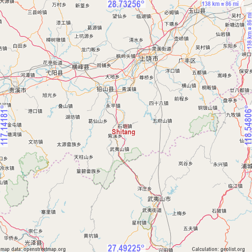
Shitang GPS coordinates[2]
28° 6' 51.12" North, 117° 50' 41.748" East
| Map corner | latitude | longitude |
|---|---|---|
| Upper-left | 28.73256°, | 117.14181° |
| Center: | 28.1142°, | 117.84493° |
| Lower-right: | 27.49225°, | 118.54806° |
| Map W x H: | 137.9×137.9 km | = 85.7×85.7mi |
| max Lat: | 53.31946° ⇑73.2% North |
| Shitang: | 28.1142° |
| min Lat: | ⇓26.8% South 18.22056° |
| min Long | Shitang | max Long |
| 75.07348° | 117.84493° | 134.28917° |
| W 70%⇐ | ⇒30% E |
Elevation
Elevation of Shitang is 148 m = 486 ft, and this is 336.8 m = 1105 ft below average elevation for this country.
| Max E: |
5622 m = 18445 ft | 52.2% |
| Avg. | 484.8 m = 1591 ft | |
| Shitang | 148 m = 486 ft | |
Min E: |
-3 m = -10 ft | 47.8% |
See also: China elevation on elevation.city.
Geographical zone
Shitang is located in North temperate zone (between Tropic of Cancer and the Arctic Circle). Distance of this Northern Tropic circle is 520.1 km =323.2 mi to South.| Distance of | km | miles | from Shitang |
|---|---|---|---|
| North Pole | 6881.1 | 4275.7 | to North |
| Arctic Circle | 4275.2 | 2656.5 | to North |
| Tropic Cancer | 520.1 | 323.2 | to South |
| Equator | 3126 | 1942.4 | to South |


Nearby cities:
15 places around Shitang: (largest is in red/bold)
• Bangluo
21.9 km =13.6 mi,  346°
346°
• Ehu
20.2 km =12.6 mi, 345°
• Gangdong
17.9 km =11.1 mi,  270°
270°
• Hongqiao
21.7 km =13.5 mi,  313°
313°
• Huanggangshan
15.4 km =9.6 mi,  221°
221°
• Huangshaling
17.9 km =11.1 mi,  36°
36°
• Jiaxuan
8.5 km =5.3 mi, 346°
• Qingxi
21.2 km =13.2 mi,  5°
5°
• Shanglu
15.6 km =9.7 mi, 39°
• Wufushan
20.1 km =12.5 mi,  80°
80°
• Wuyishan
12.6 km =7.8 mi,  195°
195°
• Yanglin
15.3 km =9.5 mi,  281°
281°
• Yingjiang
7.2 km =4.5 mi,  67°
67°
• Yongping
13.1 km =8.1 mi,  329°
329°
• Zixi
7.8 km =4.8 mi,  230°
230°
Sources, notices
• [Note1] Compared only with cities in China existing in our database
• [Src1] Map data: © OpenStreetMap contributors (CC-BY-SA)
• [Src2] Other city data from geonames.org with taken over terms of usage.
• [Src3] Geographical zone / Annual Mean Temperature by Robert A. Rohde @ Wikipedia
