Wucun geodata
Wucun (Jiangxi) is a seat of a fourth-order administrative division; located in China in Asia/Shanghai (GMT+8) time zone. In our database, there are 1268 cities with bigger population. Compared to other cities in China, 69.7% of cities are located further ↑North; 71.8% of cities are located further ←West and 53.2% of cities have lower elevation than Wucun. Note1


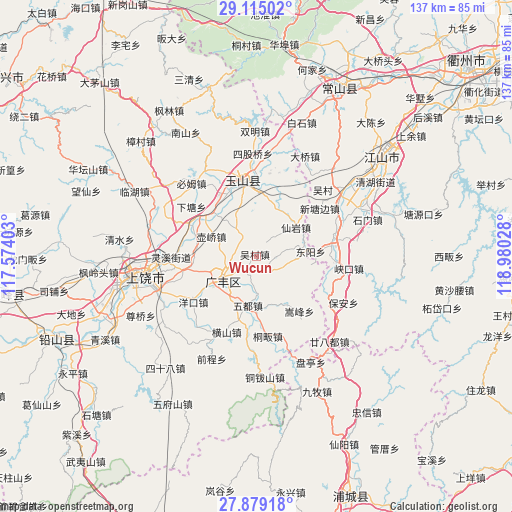
Wucun GPS coordinates[2]
28° 29' 56.076" North, 118° 16' 37.74" East
| Map corner | latitude | longitude |
|---|---|---|
| Upper-left | 29.11502°, | 117.57403° |
| Center: | 28.49891°, | 118.27715° |
| Lower-right: | 27.87918°, | 118.98028° |
| Map W x H: | 137.4×137.4 km | = 85.4×85.4mi |
| max Lat: | 53.31946° ⇑69.7% North |
| Wucun: | 28.49891° |
| min Lat: | ⇓30.3% South 18.22056° |
| min Long | Wucun | max Long |
| 75.07348° | 118.27715° | 134.28917° |
| W 71.8%⇐ | ⇒28.2% E |
Elevation
Elevation of Wucun is 190 m = 623 ft, and this is 294.8 m = 967 ft below average elevation for this country.
| Max E: |
5622 m = 18445 ft | 46.8% |
| Avg. | 484.8 m = 1591 ft | |
| Wucun | 190 m = 623 ft | |
Min E: |
-3 m = -10 ft | 53.2% |
See also: China elevation on elevation.city.
Geographical zone
Wucun is located in North temperate zone (between Tropic of Cancer and the Arctic Circle). Distance of this Northern Tropic circle is 562.9 km =349.8 mi to South.| Distance of | km | miles | from Wucun |
|---|---|---|---|
| North Pole | 6838.3 | 4249.1 | to North |
| Arctic Circle | 4232.4 | 2629.9 | to North |
| Tropic Cancer | 562.9 | 349.8 | to South |
| Equator | 3168.8 | 1969 | to South |


Nearby cities:
15 places around Wucun: (largest is in red/bold)
• Danan
6.4 km =4 mi,  329°
329°
• Dashi
12.5 km =7.8 mi,  210°
210°
• Guancun
14.6 km =9.1 mi,  100°
100°
• Huacun
10 km =6.2 mi,  9°
9°
• Hufeng
13.2 km =8.2 mi,  320°
320°
• Huqiao
12.9 km =8 mi,  295°
295°
• Liudu
16.6 km =10.3 mi, 9°
• Maocun
14.4 km =8.9 mi,  143°
143°
• Paishan
4.4 km =2.7 mi,  177°
177°
• Quanbo
14.3 km =8.9 mi,  156°
156°
• Shatian
17.9 km =11.1 mi, 178°
• Shehou
9.1 km =5.7 mi, 103°
• Xianyan
14.1 km =8.8 mi,  54°
54°
• Xiaxi
9.9 km =6.2 mi,  243°
243°
• Yongfeng
10.8 km =6.7 mi, 214°
Sources, notices
• [Note1] Compared only with cities in China existing in our database
• [Src1] Map data: © OpenStreetMap contributors (CC-BY-SA)
• [Src2] Other city data from geonames.org with taken over terms of usage.
• [Src3] Geographical zone / Annual Mean Temperature by Robert A. Rohde @ Wikipedia
