Dashi geodata
Dashi (Jiangxi) is a seat of a fourth-order administrative division; located in China in Asia/Shanghai (GMT+8) time zone. In our database, there are 1268 cities with bigger population. Compared to other cities in China, 70.6% of cities are located further ↑North; 71.5% of cities are located further ←West and 54.4% of cities have higher elevation than Dashi. Note1


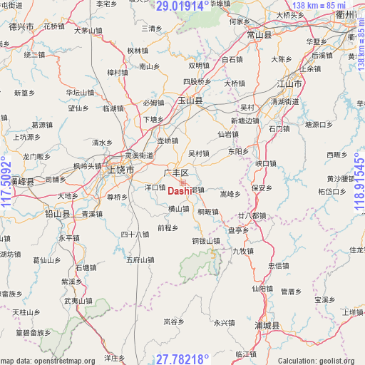
Dashi GPS coordinates[2]
28° 24' 8.892" North, 118° 12' 44.352" East
| Map corner | latitude | longitude |
|---|---|---|
| Upper-left | 29.01914°, | 117.5092° |
| Center: | 28.40247°, | 118.21232° |
| Lower-right: | 27.78218°, | 118.91545° |
| Map W x H: | 137.5×137.5 km | = 85.4×85.4mi |
| max Lat: | 53.31946° ⇑70.6% North |
| Dashi: | 28.40247° |
| min Lat: | ⇓29.4% South 18.22056° |
| min Long | Dashi | max Long |
| 75.07348° | 118.21232° | 134.28917° |
| W 71.5%⇐ | ⇒28.5% E |
Elevation
Elevation of Dashi is 135 m = 443 ft, and this is 349.8 m = 1148 ft below average elevation for this country.
| Max E: |
5622 m = 18445 ft | 54.4% |
| Avg. | 484.8 m = 1591 ft | |
| Dashi | 135 m = 443 ft | |
Min E: |
-3 m = -10 ft | 45.6% |
See also: China elevation on elevation.city.
Geographical zone
Dashi is located in North temperate zone (between Tropic of Cancer and the Arctic Circle). Distance of this Northern Tropic circle is 552.1 km =343.1 mi to South.| Distance of | km | miles | from Dashi |
|---|---|---|---|
| North Pole | 6849 | 4255.8 | to North |
| Arctic Circle | 4243.1 | 2636.5 | to North |
| Tropic Cancer | 552.1 | 343.1 | to South |
| Equator | 3158.1 | 1962.4 | to South |


Nearby cities:
15 places around Dashi: (largest is in red/bold)
• Chaoyang
14.7 km =9.1 mi,  288°
288°
• Danan
16.5 km =10.3 mi,  10°
10°
• Hengshan
9.6 km =6 mi,  188°
188°
• Hufeng
21 km =13 mi,  354°
354°
• Huqiao
17.1 km =10.6 mi,  341°
341°
• Maocun
14.9 km =9.3 mi,  93°
93°
• Paishan
9.1 km =5.7 mi,  45°
45°
• Quanbo
12.2 km =7.6 mi,  101°
101°
• Shatian
9.8 km =6.1 mi,  136°
136°
• Shehou
17.4 km =10.8 mi,  60°
60°
• Songfeng
18.4 km =11.4 mi, 104°
• Tongfan
14.2 km =8.8 mi, 137°
• Wucun
12.5 km =7.8 mi,  30°
30°
• Xiaxi
6.8 km =4.2 mi, 338°
• Yongfeng
1.8 km =1.1 mi,  4°
4°
Sources, notices
• [Note1] Compared only with cities in China existing in our database
• [Src1] Map data: © OpenStreetMap contributors (CC-BY-SA)
• [Src2] Other city data from geonames.org with taken over terms of usage.
• [Src3] Geographical zone / Annual Mean Temperature by Robert A. Rohde @ Wikipedia
