Changleng geodata
Changleng (Jiangxi) is a populated place; located in China in Asia/Shanghai (GMT+8) time zone. With population of 56,429 people, there are 777 cities with bigger population in this country. Compared to other cities in China, 68% of cities are located further ↑North; 59% of cities are located further ←West and 74.4% of cities have higher elevation than Changleng. Note1


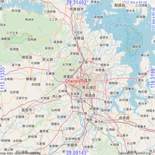
Changleng GPS coordinates[2]
28° 42' 0" North, 115° 49' 0.012" East
| Map corner | latitude | longitude |
|---|---|---|
| Upper-left | 29.31492°, | 115.11355° |
| Center: | 28.7°, | 115.81667° |
| Lower-right: | 28.08145°, | 116.5198° |
| Map W x H: | 137.1×137.2 km | = 85.2×85.3mi |
| max Lat: | 53.31946° ⇑68% North |
| Changleng: | 28.7° |
| min Lat: | ⇓32% South 18.22056° |
| min Long | Changleng | max Long |
| 75.07348° | 115.81667° | 134.28917° |
| W 59%⇐ | ⇒41% E |
Elevation
Elevation of Changleng is 38 m = 125 ft, and this is 446.8 m = 1466 ft below average elevation for this country.
| Max E: |
5622 m = 18445 ft | 74.4% |
| Avg. | 484.8 m = 1591 ft | |
| Changleng | 38 m = 125 ft | |
Min E: |
-3 m = -10 ft | 25.6% |
See also: Changleng elevation on elevation.city.
Geographical zone
Changleng is located in North temperate zone (between Tropic of Cancer and the Arctic Circle). Distance of this Northern Tropic circle is 585.2 km =363.6 mi to South.| Distance of | km | miles | from Changleng |
|---|---|---|---|
| North Pole | 6815.9 | 4235.2 | to North |
| Arctic Circle | 4210 | 2616 | to North |
| Tropic Cancer | 585.2 | 363.6 | to South |
| Equator | 3191.1 | 1982.9 | to South |


Nearby cities:
15 places around Changleng: (largest is in red/bold)
• Changjun
21 km =13 mi,  331°
331°
• Dongxin
12.4 km =7.7 mi,  174°
174°
• Fushan
20.8 km =12.9 mi, 170°
• Jiangxiangzhen
20.6 km =12.8 mi,  70°
70°
• Jiaoqiao
6.5 km =4 mi,  39°
39°
• Lehua
14.3 km =8.9 mi,  19°
19°
• Meiling
12.4 km =7.7 mi, 325°
• Nanchang
4 km =2.5 mi,  116°
116°
• Shengmi
14.3 km =8.9 mi,  189°
189°
• Taiping
15.4 km =9.6 mi,  319°
319°
• Taohua
7.6 km =4.7 mi,  133°
133°
• Wangcheng
4.5 km =2.8 mi,  229°
229°
• Xixia
17.8 km =11.1 mi,  8°
8°
• Yangzizhou
9 km =5.6 mi, 74°
• Zhaoxian
7.9 km =4.9 mi,  275°
275°
Sources, notices
• [Note1] Compared only with cities in China existing in our database
• [Src1] Map data: © OpenStreetMap contributors (CC-BY-SA)
• [Src2] Other city data from geonames.org with taken over terms of usage.
• [Src3] Geographical zone / Annual Mean Temperature by Robert A. Rohde @ Wikipedia
