Yuandu geodata
Yuandu (Jiangxi) is a seat of a fourth-order administrative division; located in China in Asia/Shanghai (GMT+8) time zone. In our database, there are 1268 cities with bigger population. Compared to other cities in China, 71.8% of cities are located further ↑North; 60.3% of cities are located further ←West and 79.8% of cities have higher elevation than Yuandu. Note1


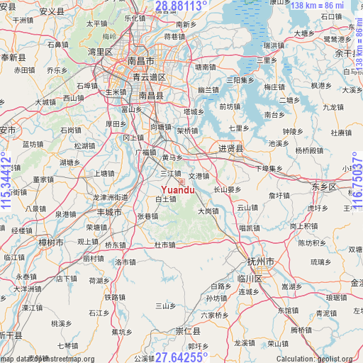
Yuandu GPS coordinates[2]
28° 15' 49.104" North, 116° 2' 50.064" East
| Map corner | latitude | longitude |
|---|---|---|
| Upper-left | 28.88113°, | 115.34412° |
| Center: | 28.26364°, | 116.04724° |
| Lower-right: | 27.64255°, | 116.75037° |
| Map W x H: | 137.7×137.7 km | = 85.6×85.6mi |
| max Lat: | 53.31946° ⇑71.8% North |
| Yuandu: | 28.26364° |
| min Lat: | ⇓28.2% South 18.22056° |
| min Long | Yuandu | max Long |
| 75.07348° | 116.04724° | 134.28917° |
| W 60.3%⇐ | ⇒39.7% E |
Elevation
Elevation of Yuandu is 27 m = 89 ft, and this is 457.8 m = 1502 ft below average elevation for this country.
| Max E: |
5622 m = 18445 ft | 79.8% |
| Avg. | 484.8 m = 1591 ft | |
| Yuandu | 27 m = 89 ft | |
Min E: |
-3 m = -10 ft | 20.2% |
See also: China elevation on elevation.city.
Geographical zone
Yuandu is located in North temperate zone (between Tropic of Cancer and the Arctic Circle). Distance of this Northern Tropic circle is 536.7 km =333.5 mi to South.| Distance of | km | miles | from Yuandu |
|---|---|---|---|
| North Pole | 6864.4 | 4265.3 | to North |
| Arctic Circle | 4258.6 | 2646.2 | to North |
| Tropic Cancer | 536.7 | 333.5 | to South |
| Equator | 3142.6 | 1952.7 | to South |


Nearby cities:
15 places around Yuandu: (largest is in red/bold)
• Baitu
8.8 km =5.5 mi,  225°
225°
• Baixu
20.1 km =12.5 mi,  90°
90°
• Changshanyan
17.4 km =10.8 mi,  98°
98°
• Dagang
17.3 km =10.7 mi,  134°
134°
• Duantan
9.3 km =5.8 mi,  273°
273°
• Huangma
10.4 km =6.5 mi,  340°
340°
• Liduzhen
11.6 km =7.2 mi,  112°
112°
• Luoxi
19.6 km =12.2 mi,  31°
31°
• Quanling
12.9 km =8 mi,  10°
10°
• Sanjiang
5.3 km =3.3 mi,  307°
307°
• Wengang
6.5 km =4 mi,  67°
67°
• Xiangtang
19.9 km =12.4 mi, 335°
• Xiaogang
18.2 km =11.3 mi,  264°
264°
• Xiaotang
14.6 km =9.1 mi,  245°
245°
• Zhangxiang
18.3 km =11.4 mi, 226°
Sources, notices
• [Note1] Compared only with cities in China existing in our database
• [Src1] Map data: © OpenStreetMap contributors (CC-BY-SA)
• [Src2] Other city data from geonames.org with taken over terms of usage.
• [Src3] Geographical zone / Annual Mean Temperature by Robert A. Rohde @ Wikipedia
