Huangma geodata
Huangma (Jiangxi) is a seat of a fourth-order administrative division; located in China in Asia/Shanghai (GMT+8) time zone. In our database, there are 1268 cities with bigger population. Compared to other cities in China, 71% of cities are located further ↑North; 60.2% of cities are located further ←West and 75.7% of cities have higher elevation than Huangma. Note1


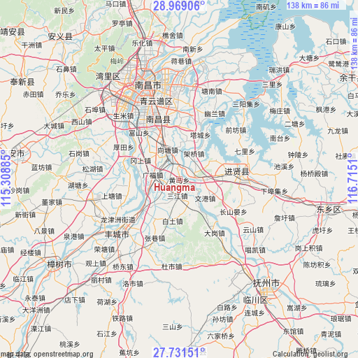
Huangma GPS coordinates[2]
28° 21' 7.524" North, 116° 0' 43.092" East
| Map corner | latitude | longitude |
|---|---|---|
| Upper-left | 28.96906°, | 115.30885° |
| Center: | 28.35209°, | 116.01197° |
| Lower-right: | 27.73151°, | 116.7151° |
| Map W x H: | 137.6×137.6 km | = 85.5×85.5mi |
| max Lat: | 53.31946° ⇑71% North |
| Huangma: | 28.35209° |
| min Lat: | ⇓29% South 18.22056° |
| min Long | Huangma | max Long |
| 75.07348° | 116.01197° | 134.28917° |
| W 60.2%⇐ | ⇒39.8% E |
Elevation
Elevation of Huangma is 35 m = 115 ft, and this is 449.8 m = 1476 ft below average elevation for this country.
| Max E: |
5622 m = 18445 ft | 75.7% |
| Avg. | 484.8 m = 1591 ft | |
| Huangma | 35 m = 115 ft | |
Min E: |
-3 m = -10 ft | 24.3% |
See also: China elevation on elevation.city.
Geographical zone
Huangma is located in North temperate zone (between Tropic of Cancer and the Arctic Circle). Distance of this Northern Tropic circle is 546.5 km =339.6 mi to South.| Distance of | km | miles | from Huangma |
|---|---|---|---|
| North Pole | 6854.6 | 4259.2 | to North |
| Arctic Circle | 4248.7 | 2640 | to North |
| Tropic Cancer | 546.5 | 339.6 | to South |
| Equator | 3152.5 | 1958.9 | to South |


Nearby cities:
15 places around Huangma: (largest is in red/bold)
• Baitu
16.3 km =10.1 mi,  189°
189°
• Duantan
11 km =6.8 mi,  212°
212°
• Gangshang
16.2 km =10.1 mi,  296°
296°
• Liduzhen
20.1 km =12.5 mi,  135°
135°
• Luoxi
15.3 km =9.5 mi,  62°
62°
• Quanling
6.5 km =4 mi, 63°
• Sanjiang
6.6 km =4.1 mi, 186°
• Tacheng
19 km =11.8 mi,  24°
24°
• Tongtianxiang
19.9 km =12.4 mi,  263°
263°
• Wengang
11.9 km =7.4 mi,  127°
127°
• Wuyang
18.5 km =11.5 mi,  359°
359°
• Xiangtang
9.5 km =5.9 mi,  330°
330°
• Xiaogang
18.7 km =11.6 mi,  231°
231°
• Xiaotang
18.7 km =11.6 mi, 211°
• Yuandu
10.4 km =6.5 mi,  160°
160°
Sources, notices
• [Note1] Compared only with cities in China existing in our database
• [Src1] Map data: © OpenStreetMap contributors (CC-BY-SA)
• [Src2] Other city data from geonames.org with taken over terms of usage.
• [Src3] Geographical zone / Annual Mean Temperature by Robert A. Rohde @ Wikipedia
