Baisha geodata
Baisha (Hunan) is a seat of a fourth-order administrative division; located in China in Asia/Shanghai (GMT+8) time zone. In our database, there are 1268 cities with bigger population. Compared to other cities in China, 66% of cities are located further ↑North; 60.7% of cities are located further →East and 78.3% of cities have higher elevation than Baisha. Note1


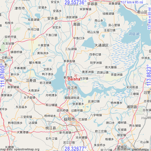
Baisha GPS coordinates[2]
28° 56' 38.004" North, 112° 22' 45.012" East
| Map corner | latitude | longitude |
|---|---|---|
| Upper-left | 29.55736°, | 111.67605° |
| Center: | 28.94389°, | 112.37917° |
| Lower-right: | 28.32677°, | 113.0823° |
| Map W x H: | 136.8×136.8 km | = 85×85mi |
| max Lat: | 53.31946° ⇑66% North |
| Baisha: | 28.94389° |
| min Lat: | ⇓34% South 18.22056° |
| min Long | Baisha | max Long |
| 75.07348° | 112.37917° | 134.28917° |
| W 39.3%⇐ | ⇒60.7% E |
Elevation
Elevation of Baisha is 30 m = 98 ft, and this is 454.8 m = 1492 ft below average elevation for this country.
| Max E: |
5622 m = 18445 ft | 78.3% |
| Avg. | 484.8 m = 1591 ft | |
| Baisha | 30 m = 98 ft | |
Min E: |
-3 m = -10 ft | 21.7% |
See also: China elevation on elevation.city.
Geographical zone
Baisha is located in North temperate zone (between Tropic of Cancer and the Arctic Circle). Distance of this Northern Tropic circle is 612.3 km =380.5 mi to South.| Distance of | km | miles | from Baisha |
|---|---|---|---|
| North Pole | 6788.8 | 4218.4 | to North |
| Arctic Circle | 4182.9 | 2599.1 | to North |
| Tropic Cancer | 612.3 | 380.5 | to South |
| Equator | 3218.3 | 1999.8 | to South |


Nearby cities:
15 places around Baisha: (largest is in red/bold)
• Cihukou
28.8 km =17.9 mi,  144°
144°
• Damatou
36.5 km =22.7 mi,  186°
186°
• Datong
13.5 km =8.4 mi,  15°
15°
• Huangzhuzhou
34.5 km =21.4 mi,  303°
303°
• Jiangjiazui
20.5 km =12.7 mi,  228°
228°
• Junshanpu
33.9 km =21.1 mi,  218°
218°
• Nandashan
33.4 km =20.8 mi,  76°
76°
• Qionghu
11.5 km =7.1 mi,  182°
182°
• Sanchahe
20.9 km =13 mi,  337°
337°
• Sanyantang
19.8 km =12.3 mi, 186°
• Sijihong
25.9 km =16.1 mi,  45°
45°
• Yangluozhou
22.5 km =14 mi,  58°
58°
• Yingfengqiao
33.4 km =20.8 mi,  199°
199°
• Zhoukou
33.5 km =20.8 mi,  283°
283°
• Zhouwenmiao
32.1 km =19.9 mi,  263°
263°
Sources, notices
• [Note1] Compared only with cities in China existing in our database
• [Src1] Map data: © OpenStreetMap contributors (CC-BY-SA)
• [Src2] Other city data from geonames.org with taken over terms of usage.
• [Src3] Geographical zone / Annual Mean Temperature by Robert A. Rohde @ Wikipedia
