Sanchahe geodata
Sanchahe (Hunan) is a seat of a fourth-order administrative division; located in China in Asia/Shanghai (GMT+8) time zone. In our database, there are 1268 cities with bigger population. Compared to other cities in China, 64.1% of cities are located further ↑North; 61.1% of cities are located further →East and 77.7% of cities have higher elevation than Sanchahe. Note1


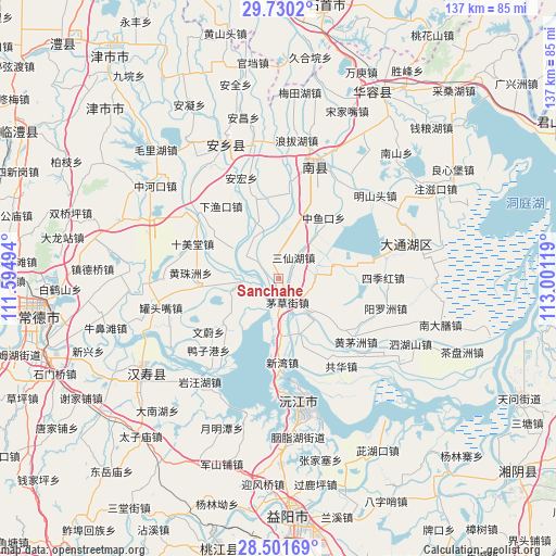
Sanchahe GPS coordinates[2]
29° 7' 4.008" North, 112° 17' 53.016" East
| Map corner | latitude | longitude |
|---|---|---|
| Upper-left | 29.7302°, | 111.59494° |
| Center: | 29.11778°, | 112.29806° |
| Lower-right: | 28.50169°, | 113.00119° |
| Map W x H: | 136.6×136.6 km | = 84.9×84.9mi |
| max Lat: | 53.31946° ⇑64.1% North |
| Sanchahe: | 29.11778° |
| min Lat: | ⇓35.9% South 18.22056° |
| min Long | Sanchahe | max Long |
| 75.07348° | 112.29806° | 134.28917° |
| W 38.9%⇐ | ⇒61.1% E |
Elevation
Elevation of Sanchahe is 31 m = 102 ft, and this is 453.8 m = 1489 ft below average elevation for this country.
| Max E: |
5622 m = 18445 ft | 77.7% |
| Avg. | 484.8 m = 1591 ft | |
| Sanchahe | 31 m = 102 ft | |
Min E: |
-3 m = -10 ft | 22.3% |
See also: China elevation on elevation.city.
Geographical zone
Sanchahe is located in North temperate zone (between Tropic of Cancer and the Arctic Circle). Distance of this Northern Tropic circle is 631.7 km =392.5 mi to South.| Distance of | km | miles | from Sanchahe |
|---|---|---|---|
| North Pole | 6769.5 | 4206.4 | to North |
| Arctic Circle | 4163.6 | 2587.1 | to North |
| Tropic Cancer | 631.7 | 392.5 | to South |
| Equator | 3237.6 | 2011.8 | to South |


Nearby cities:
15 places around Sanchahe: (largest is in red/bold)
• Baisha
20.9 km =13 mi,  157°
157°
• Datong
13.1 km =8.1 mi,  118°
118°
• Guantouzui
29.7 km =18.5 mi,  255°
255°
• Haozigang
29 km =18 mi,  306°
306°
• Heishanzui
28.1 km =17.5 mi,  268°
268°
• Huangzhuzhou
20.7 km =12.9 mi, 269°
• Mahekou
20.1 km =12.5 mi,  355°
355°
• Nanzhou
28.7 km =17.8 mi,  20°
20°
• Qionghu
31.7 km =19.7 mi,  166°
166°
• Shimeitang
23.7 km =14.7 mi,  290°
290°
• Sijihong
26.5 km =16.5 mi,  92°
92°
• Yangluozhou
28.1 km =17.5 mi,  105°
105°
• Zhoukou
27.1 km =16.8 mi,  245°
245°
• Zhouwenmiao
33.1 km =20.6 mi,  226°
226°
• Zhufeng
33.2 km =20.6 mi, 288°
Sources, notices
• [Note1] Compared only with cities in China existing in our database
• [Src1] Map data: © OpenStreetMap contributors (CC-BY-SA)
• [Src2] Other city data from geonames.org with taken over terms of usage.
• [Src3] Geographical zone / Annual Mean Temperature by Robert A. Rohde @ Wikipedia
