Cihukou geodata
Cihukou (Hunan) is a seat of a fourth-order administrative division; located in China in Asia/Shanghai (GMT+8) time zone. In our database, there are 1268 cities with bigger population. Compared to other cities in China, 67.7% of cities are located further ↑North; 59.8% of cities are located further →East and 78.3% of cities have higher elevation than Cihukou. Note1


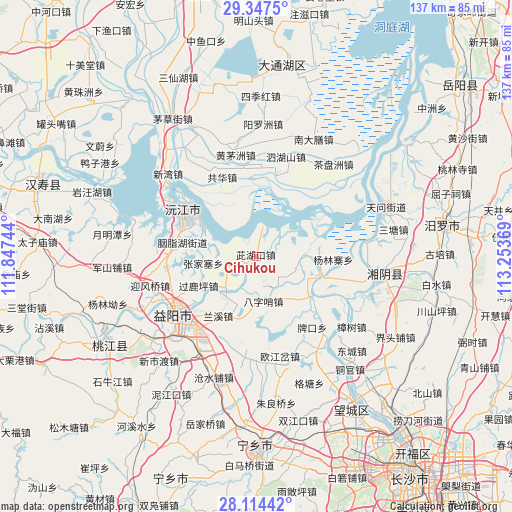
Cihukou GPS coordinates[2]
28° 43' 58.008" North, 112° 33' 2.016" East
| Map corner | latitude | longitude |
|---|---|---|
| Upper-left | 29.3475°, | 111.84744° |
| Center: | 28.73278°, | 112.55056° |
| Lower-right: | 28.11442°, | 113.25369° |
| Map W x H: | 137.1×137.1 km | = 85.2×85.2mi |
| max Lat: | 53.31946° ⇑67.7% North |
| Cihukou: | 28.73278° |
| min Lat: | ⇓32.3% South 18.22056° |
| min Long | Cihukou | max Long |
| 75.07348° | 112.55056° | 134.28917° |
| W 40.2%⇐ | ⇒59.8% E |
Elevation
Elevation of Cihukou is 30 m = 98 ft, and this is 454.8 m = 1492 ft below average elevation for this country.
| Max E: |
5622 m = 18445 ft | 78.3% |
| Avg. | 484.8 m = 1591 ft | |
| Cihukou | 30 m = 98 ft | |
Min E: |
-3 m = -10 ft | 21.7% |
See also: China elevation on elevation.city.
Geographical zone
Cihukou is located in North temperate zone (between Tropic of Cancer and the Arctic Circle). Distance of this Northern Tropic circle is 588.9 km =365.9 mi to South.| Distance of | km | miles | from Cihukou |
|---|---|---|---|
| North Pole | 6812.3 | 4233 | to North |
| Arctic Circle | 4206.4 | 2613.7 | to North |
| Tropic Cancer | 588.9 | 365.9 | to South |
| Equator | 3194.8 | 1985.2 | to South |


Nearby cities:
15 places around Cihukou: (largest is in red/bold)
• Baisha
28.8 km =17.9 mi,  324°
324°
• Bazishao
12.6 km =7.8 mi,  173°
173°
• Damatou
24.5 km =15.2 mi,  238°
238°
• Heshan
25.7 km =16 mi,  229°
229°
• Oujiangcha
29.7 km =18.5 mi, 171°
• Qiaokou
31.2 km =19.4 mi,  145°
145°
• Qingtan
31.9 km =19.8 mi,  63°
63°
• Qionghu
21 km =13 mi,  304°
304°
• Sanyantang
19.3 km =12 mi,  281°
281°
• Wenxing
32.5 km =20.2 mi,  99°
99°
• Xinquansi
18.4 km =11.4 mi,  129°
129°
• Yanglinzhai
16.6 km =10.3 mi,  76°
76°
• Yingfengqiao
29.1 km =18.1 mi,  254°
254°
• Yiyang
26.9 km =16.7 mi, 233°
• Zhangshu
31.7 km =19.7 mi, 126°
Sources, notices
• [Note1] Compared only with cities in China existing in our database
• [Src1] Map data: © OpenStreetMap contributors (CC-BY-SA)
• [Src2] Other city data from geonames.org with taken over terms of usage.
• [Src3] Geographical zone / Annual Mean Temperature by Robert A. Rohde @ Wikipedia
