Xintang geodata
Xintang (Hunan) is a seat of a fourth-order administrative division; located in China in Asia/Shanghai (GMT+8) time zone. In our database, there are 1268 cities with bigger population. Compared to other cities in China, 65.5% of cities are located further ↑North; 57.4% of cities are located further →East and 74.4% of cities have higher elevation than Xintang. Note1


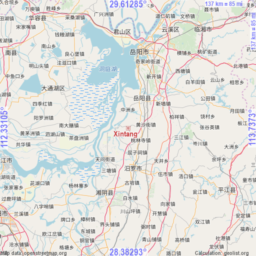
Xintang GPS coordinates[2]
28° 59' 58.992" North, 113° 2' 3.012" East
| Map corner | latitude | longitude |
|---|---|---|
| Upper-left | 29.61285°, | 112.33105° |
| Center: | 28.99972°, | 113.03417° |
| Lower-right: | 28.38293°, | 113.7373° |
| Map W x H: | 136.8×136.8 km | = 85×85mi |
| max Lat: | 53.31946° ⇑65.5% North |
| Xintang: | 28.99972° |
| min Lat: | ⇓34.5% South 18.22056° |
| min Long | Xintang | max Long |
| 75.07348° | 113.03417° | 134.28917° |
| W 42.6%⇐ | ⇒57.4% E |
Elevation
Elevation of Xintang is 38 m = 125 ft, and this is 446.8 m = 1466 ft below average elevation for this country.
| Max E: |
5622 m = 18445 ft | 74.4% |
| Avg. | 484.8 m = 1591 ft | |
| Xintang | 38 m = 125 ft | |
Min E: |
-3 m = -10 ft | 25.6% |
See also: China elevation on elevation.city.
Geographical zone
Xintang is located in North temperate zone (between Tropic of Cancer and the Arctic Circle). Distance of this Northern Tropic circle is 618.5 km =384.3 mi to South.| Distance of | km | miles | from Xintang |
|---|---|---|---|
| North Pole | 6782.6 | 4214.5 | to North |
| Arctic Circle | 4176.7 | 2595.3 | to North |
| Tropic Cancer | 618.5 | 384.3 | to South |
| Equator | 3224.5 | 2003.6 | to South |


Nearby cities:
15 places around Xintang: (largest is in red/bold)
• Baishui
38 km =23.6 mi,  176°
176°
• Beizhouzi
38.4 km =23.9 mi,  298°
298°
• Dongtang
25.5 km =15.8 mi,  194°
194°
• Fanjiayuan
13.7 km =8.5 mi,  157°
157°
• Lujiao
17.3 km =10.7 mi,  351°
351°
• Miluo Chengguanzhen
21.2 km =13.2 mi,  171°
171°
• Nandashan
31.2 km =19.4 mi,  272°
272°
• Qingtan
24.1 km =15 mi,  229°
229°
• Rongjiawan
18 km =11.2 mi,  21°
21°
• Sijihong
46.6 km =29 mi,  284°
284°
• Tuanzhou
44.9 km =27.9 mi,  325°
325°
• Wenxing
38.4 km =23.9 mi,  203°
203°
• Yanglinzhai
40.3 km =25 mi, 230°
• Yangluozhou
44.9 km =27.9 mi, 277°
• Yueyang
42.1 km =26.2 mi,  8°
8°
Sources, notices
• [Note1] Compared only with cities in China existing in our database
• [Src1] Map data: © OpenStreetMap contributors (CC-BY-SA)
• [Src2] Other city data from geonames.org with taken over terms of usage.
• [Src3] Geographical zone / Annual Mean Temperature by Robert A. Rohde @ Wikipedia
