Qingtan geodata
Qingtan (Hunan) is a seat of a fourth-order administrative division; located in China in Asia/Shanghai (GMT+8) time zone. In our database, there are 1268 cities with bigger population. Compared to other cities in China, 66.7% of cities are located further ↑North; 58.4% of cities are located further →East and 80.8% of cities have higher elevation than Qingtan. Note1


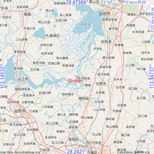
Qingtan GPS coordinates[2]
28° 51' 34.992" North, 112° 50' 39.984" East
| Map corner | latitude | longitude |
|---|---|---|
| Upper-left | 29.47369°, | 112.14132° |
| Center: | 28.85972°, | 112.84444° |
| Lower-right: | 28.2421°, | 113.54757° |
| Map W x H: | 136.9×136.9 km | = 85.1×85.1mi |
| max Lat: | 53.31946° ⇑66.7% North |
| Qingtan: | 28.85972° |
| min Lat: | ⇓33.3% South 18.22056° |
| min Long | Qingtan | max Long |
| 75.07348° | 112.84444° | 134.28917° |
| W 41.6%⇐ | ⇒58.4% E |
Elevation
Elevation of Qingtan is 25 m = 82 ft, and this is 459.8 m = 1509 ft below average elevation for this country.
| Max E: |
5622 m = 18445 ft | 80.8% |
| Avg. | 484.8 m = 1591 ft | |
| Qingtan | 25 m = 82 ft | |
Min E: |
-3 m = -10 ft | 19.2% |
See also: China elevation on elevation.city.
Geographical zone
Qingtan is located in North temperate zone (between Tropic of Cancer and the Arctic Circle). Distance of this Northern Tropic circle is 603 km =374.7 mi to South.| Distance of | km | miles | from Qingtan |
|---|---|---|---|
| North Pole | 6798.2 | 4224.2 | to North |
| Arctic Circle | 4192.3 | 2605 | to North |
| Tropic Cancer | 603 | 374.7 | to South |
| Equator | 3208.9 | 1993.9 | to South |


Nearby cities:
15 places around Qingtan: (largest is in red/bold)
• Baishui
30.6 km =19 mi,  136°
136°
• Beizhouzi
37.2 km =23.1 mi,  335°
335°
• Cihukou
31.9 km =19.8 mi,  243°
243°
• Dongtang
15.2 km =9.4 mi,  126°
126°
• Fanjiayuan
23.8 km =14.8 mi,  83°
83°
• Lujiao
36.3 km =22.6 mi,  25°
25°
• Miluo Chengguanzhen
22.3 km =13.9 mi,  104°
104°
• Nandashan
21.2 km =13.2 mi,  323°
323°
• Wenxing
20 km =12.4 mi,  170°
170°
• Xinquansi
29.4 km =18.3 mi,  209°
209°
• Xintang
24.1 km =15 mi,  49°
49°
• Yanglinzhai
16.2 km =10.1 mi,  230°
230°
• Yangluozhou
33.6 km =20.9 mi,  308°
308°
• Yuhua
32.7 km =20.3 mi,  161°
161°
• Zhangshu
33.1 km =20.6 mi,  185°
185°
Sources, notices
• [Note1] Compared only with cities in China existing in our database
• [Src1] Map data: © OpenStreetMap contributors (CC-BY-SA)
• [Src2] Other city data from geonames.org with taken over terms of usage.
• [Src3] Geographical zone / Annual Mean Temperature by Robert A. Rohde @ Wikipedia
