Fengshu geodata
Fengshu (Hunan) is a seat of a fourth-order administrative division; located in China in Asia/Shanghai (GMT+8) time zone. In our database, there are 1268 cities with bigger population. Compared to other cities in China, 65.3% of cities are located further ↑North; 65.1% of cities are located further →East and 73.3% of cities have higher elevation than Fengshu. Note1


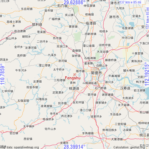
Fengshu GPS coordinates[2]
29° 0' 56.988" North, 111° 29' 20.472" East
| Map corner | latitude | longitude |
|---|---|---|
| Upper-left | 29.62886°, | 110.7859° |
| Center: | 29.01583°, | 111.48902° |
| Lower-right: | 28.39914°, | 112.19215° |
| Map W x H: | 136.7×136.7 km | = 84.9×84.9mi |
| max Lat: | 53.31946° ⇑65.3% North |
| Fengshu: | 29.01583° |
| min Lat: | ⇓34.7% South 18.22056° |
| min Long | Fengshu | max Long |
| 75.07348° | 111.48902° | 134.28917° |
| W 34.9%⇐ | ⇒65.1% E |
Elevation
Elevation of Fengshu is 41 m = 135 ft, and this is 443.8 m = 1456 ft below average elevation for this country.
| Max E: |
5622 m = 18445 ft | 73.3% |
| Avg. | 484.8 m = 1591 ft | |
| Fengshu | 41 m = 135 ft | |
Min E: |
-3 m = -10 ft | 26.7% |
See also: China elevation on elevation.city.
Geographical zone
Fengshu is located in North temperate zone (between Tropic of Cancer and the Arctic Circle). Distance of this Northern Tropic circle is 620.3 km =385.4 mi to South.| Distance of | km | miles | from Fengshu |
|---|---|---|---|
| North Pole | 6780.8 | 4213.4 | to North |
| Arctic Circle | 4174.9 | 2594.2 | to North |
| Tropic Cancer | 620.3 | 385.4 | to South |
| Equator | 3226.3 | 2004.7 | to South |


Nearby cities:
15 places around Fengshu: (largest is in red/bold)
• Chehuyuan
6.8 km =4.2 mi,  162°
162°
• Danzhou
14.2 km =8.8 mi,  92°
92°
• Dingjiagang
16.5 km =10.3 mi, 155°
• Doumuhu
15.5 km =9.6 mi,  118°
118°
• Guanxi
16.4 km =10.2 mi,  49°
49°
• Hefu
10.8 km =6.7 mi,  76°
76°
• Mutangyuan
5.9 km =3.7 mi, 90°
• Qinglin
7.1 km =4.4 mi,  195°
195°
• Sanyanggang
14.6 km =9.1 mi,  252°
252°
• Shenshuigang
14.2 km =8.8 mi,  218°
218°
• Taipingqiao
15.6 km =9.7 mi,  289°
289°
• Wuxihe
7.3 km =4.5 mi,  276°
276°
• Xujiaqiao
14.7 km =9.1 mi,  140°
140°
• Zhangjiang
11.7 km =7.3 mi,  184°
184°
• Zoushi
5.8 km =3.6 mi,  57°
57°
Sources, notices
• [Note1] Compared only with cities in China existing in our database
• [Src1] Map data: © OpenStreetMap contributors (CC-BY-SA)
• [Src2] Other city data from geonames.org with taken over terms of usage.
• [Src3] Geographical zone / Annual Mean Temperature by Robert A. Rohde @ Wikipedia
