Dingjiagang geodata
Dingjiagang (Hunan) is a seat of a fourth-order administrative division; located in China in Asia/Shanghai (GMT+8) time zone. In our database, there are 1268 cities with bigger population. Compared to other cities in China, 66.6% of cities are located further ↑North; 64.8% of cities are located further →East and 60.1% of cities have higher elevation than Dingjiagang. Note1


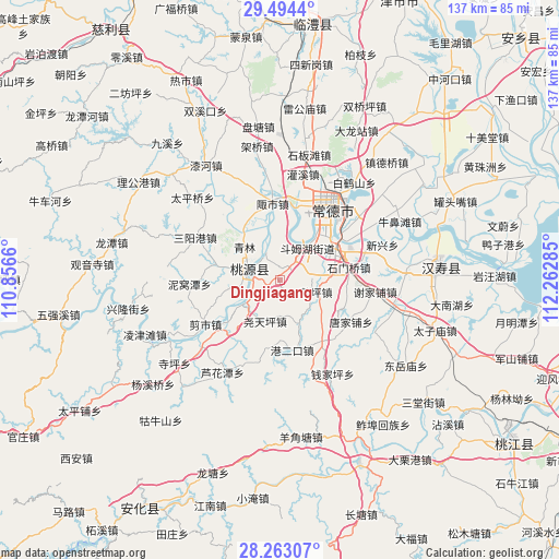
Dingjiagang GPS coordinates[2]
28° 52' 50.016" North, 111° 33' 34.992" East
| Map corner | latitude | longitude |
|---|---|---|
| Upper-left | 29.4944°, | 110.8566° |
| Center: | 28.88056°, | 111.55972° |
| Lower-right: | 28.26307°, | 112.26285° |
| Map W x H: | 136.9×136.9 km | = 85.1×85.1mi |
| max Lat: | 53.31946° ⇑66.6% North |
| Dingjiagang: | 28.88056° |
| min Lat: | ⇓33.4% South 18.22056° |
| min Long | Dingjiagang | max Long |
| 75.07348° | 111.55972° | 134.28917° |
| W 35.2%⇐ | ⇒64.8% E |
Elevation
Elevation of Dingjiagang is 98 m = 322 ft, and this is 386.8 m = 1269 ft below average elevation for this country.
| Max E: |
5622 m = 18445 ft | 60.1% |
| Avg. | 484.8 m = 1591 ft | |
| Dingjiagang | 98 m = 322 ft | |
Min E: |
-3 m = -10 ft | 39.9% |
See also: China elevation on elevation.city.
Geographical zone
Dingjiagang is located in North temperate zone (between Tropic of Cancer and the Arctic Circle). Distance of this Northern Tropic circle is 605.3 km =376.1 mi to South.| Distance of | km | miles | from Dingjiagang |
|---|---|---|---|
| North Pole | 6795.8 | 4222.7 | to North |
| Arctic Circle | 4190 | 2603.5 | to North |
| Tropic Cancer | 605.3 | 376.1 | to South |
| Equator | 3211.2 | 1995.3 | to South |


Nearby cities:
15 places around Dingjiagang: (largest is in red/bold)
• Changmaoling
11.3 km =7 mi,  158°
158°
• Chehuyuan
9.8 km =6.1 mi,  330°
330°
• Danzhou
16.1 km =10 mi,  27°
27°
• Deshan
15.8 km =9.8 mi,  70°
70°
• Doumuhu
10.1 km =6.3 mi,  41°
41°
• Fengshu
16.5 km =10.3 mi,  335°
335°
• Hefu
17.9 km =11.1 mi,  11°
11°
• Mutangyuan
15.1 km =9.4 mi,  356°
356°
• Qinglin
12.1 km =7.5 mi,  312°
312°
• Shenshuigang
16.2 km =10.1 mi,  284°
284°
• Shimenqiao
17.4 km =10.8 mi,  80°
80°
• Taohuayuan
16.3 km =10.1 mi,  223°
223°
• Xujiaqiao
4.4 km =2.7 mi, 33°
• Zhangjiang
8.5 km =5.3 mi,  293°
293°
• Zoushi
18.3 km =11.4 mi,  353°
353°
Sources, notices
• [Note1] Compared only with cities in China existing in our database
• [Src1] Map data: © OpenStreetMap contributors (CC-BY-SA)
• [Src2] Other city data from geonames.org with taken over terms of usage.
• [Src3] Geographical zone / Annual Mean Temperature by Robert A. Rohde @ Wikipedia
