Baiheshan geodata
Baiheshan (Hunan) is a seat of a fourth-order administrative division; located in China in Asia/Shanghai (GMT+8) time zone. In our database, there are 1268 cities with bigger population. Compared to other cities in China, 64.2% of cities are located further ↑North; 63.5% of cities are located further →East and 78.8% of cities have higher elevation than Baiheshan. Note1


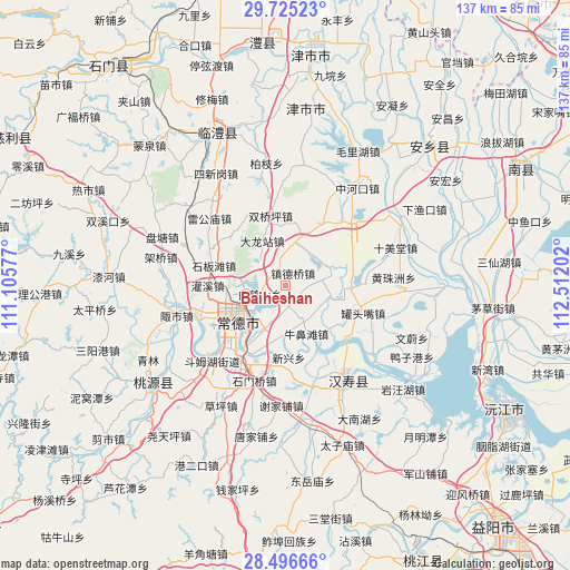
Baiheshan GPS coordinates[2]
29° 6' 46.008" North, 111° 48' 32.004" East
| Map corner | latitude | longitude |
|---|---|---|
| Upper-left | 29.72523°, | 111.10577° |
| Center: | 29.11278°, | 111.80889° |
| Lower-right: | 28.49666°, | 112.51202° |
| Map W x H: | 136.6×136.6 km | = 84.9×84.9mi |
| max Lat: | 53.31946° ⇑64.2% North |
| Baiheshan: | 29.11278° |
| min Lat: | ⇓35.8% South 18.22056° |
| min Long | Baiheshan | max Long |
| 75.07348° | 111.80889° | 134.28917° |
| W 36.5%⇐ | ⇒63.5% E |
Elevation
Elevation of Baiheshan is 29 m = 95 ft, and this is 455.8 m = 1495 ft below average elevation for this country.
| Max E: |
5622 m = 18445 ft | 78.8% |
| Avg. | 484.8 m = 1591 ft | |
| Baiheshan | 29 m = 95 ft | |
Min E: |
-3 m = -10 ft | 21.2% |
See also: China elevation on elevation.city.
Geographical zone
Baiheshan is located in North temperate zone (between Tropic of Cancer and the Arctic Circle). Distance of this Northern Tropic circle is 631.1 km =392.1 mi to South.| Distance of | km | miles | from Baiheshan |
|---|---|---|---|
| North Pole | 6770 | 4206.7 | to North |
| Arctic Circle | 4164.1 | 2587.5 | to North |
| Tropic Cancer | 631.1 | 392.1 | to South |
| Equator | 3237 | 2011.4 | to South |


Nearby cities:
15 places around Baiheshan: (largest is in red/bold)
• Changde
14.7 km =9.1 mi,  239°
239°
• Dalongzhan
11.6 km =7.2 mi,  332°
332°
• Dingcheng
16.3 km =10.1 mi,  230°
230°
• Dongjiang
10.6 km =6.6 mi,  214°
214°
• Dongjiao
14 km =8.7 mi,  223°
223°
• Hangongdu
11 km =6.8 mi,  103°
103°
• Hucheng
14.3 km =8.9 mi, 236°
• Hucheng
16.4 km =10.2 mi, 242°
• Ludishan
14 km =8.7 mi, 210°
• Nanpinggang
13.1 km =8.1 mi,  246°
246°
• Niubitan
12.6 km =7.8 mi,  156°
156°
• Shigongqiao
9.6 km =6 mi,  35°
35°
• Xinxing
17.4 km =10.8 mi,  175°
175°
• Zhendeqiao
3.4 km =2.1 mi,  33°
33°
• Zhoujiadian
17.4 km =10.8 mi, 30°
Sources, notices
• [Note1] Compared only with cities in China existing in our database
• [Src1] Map data: © OpenStreetMap contributors (CC-BY-SA)
• [Src2] Other city data from geonames.org with taken over terms of usage.
• [Src3] Geographical zone / Annual Mean Temperature by Robert A. Rohde @ Wikipedia
