Ludishan geodata
Ludishan (Hunan) is a seat of a fourth-order administrative division; located in China in Asia/Shanghai (GMT+8) time zone. In our database, there are 1268 cities with bigger population. Compared to other cities in China, 65.4% of cities are located further ↑North; 63.8% of cities are located further →East and 74.8% of cities have higher elevation than Ludishan. Note1


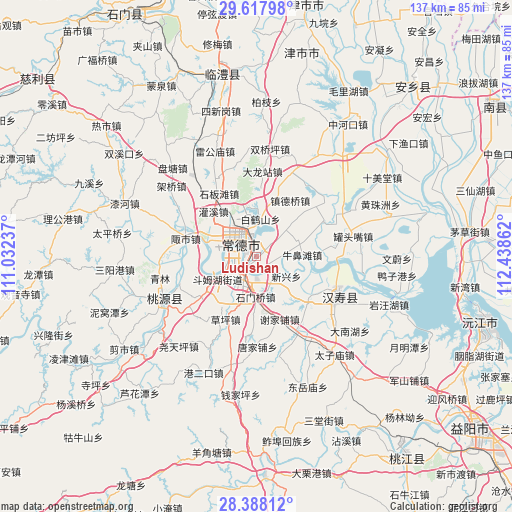
Ludishan GPS coordinates[2]
29° 0' 17.568" North, 111° 44' 7.764" East
| Map corner | latitude | longitude |
|---|---|---|
| Upper-left | 29.61798°, | 111.03237° |
| Center: | 29.00488°, | 111.73549° |
| Lower-right: | 28.38812°, | 112.43862° |
| Map W x H: | 136.7×136.7 km | = 84.9×84.9mi |
| max Lat: | 53.31946° ⇑65.4% North |
| Ludishan: | 29.00488° |
| min Lat: | ⇓34.6% South 18.22056° |
| min Long | Ludishan | max Long |
| 75.07348° | 111.73549° | 134.28917° |
| W 36.2%⇐ | ⇒63.8% E |
Elevation
Elevation of Ludishan is 37 m = 121 ft, and this is 447.8 m = 1469 ft below average elevation for this country.
| Max E: |
5622 m = 18445 ft | 74.8% |
| Avg. | 484.8 m = 1591 ft | |
| Ludishan | 37 m = 121 ft | |
Min E: |
-3 m = -10 ft | 25.2% |
See also: China elevation on elevation.city.
Geographical zone
Ludishan is located in North temperate zone (between Tropic of Cancer and the Arctic Circle). Distance of this Northern Tropic circle is 619.1 km =384.7 mi to South.| Distance of | km | miles | from Ludishan |
|---|---|---|---|
| North Pole | 6782 | 4214.1 | to North |
| Arctic Circle | 4176.1 | 2594.9 | to North |
| Tropic Cancer | 619.1 | 384.7 | to South |
| Equator | 3225 | 2003.9 | to South |


Nearby cities:
15 places around Ludishan: (largest is in red/bold)
• Baiheshan
14 km =8.7 mi,  30°
30°
• Changde
7.2 km =4.5 mi,  309°
309°
• Danzhou
9.8 km =6.1 mi,  273°
273°
• Deshan
8.8 km =5.5 mi,  194°
194°
• Dingcheng
5.7 km =3.5 mi,  286°
286°
• Dongjiang
3.4 km =2.1 mi,  18°
18°
• Dongjiao
3.1 km =1.9 mi, 306°
• Doumuhu
12.1 km =7.5 mi,  239°
239°
• Hefu
14 km =8.7 mi, 285°
• Hucheng
6.3 km =3.9 mi, 310°
• Hucheng
8.7 km =5.4 mi,  300°
300°
• Nanpinggang
8.3 km =5.2 mi,  323°
323°
• Niubitan
12.1 km =7.5 mi,  88°
88°
• Shimenqiao
11.1 km =6.9 mi,  179°
179°
• Xinxing
10.1 km =6.3 mi,  121°
121°
Sources, notices
• [Note1] Compared only with cities in China existing in our database
• [Src1] Map data: © OpenStreetMap contributors (CC-BY-SA)
• [Src2] Other city data from geonames.org with taken over terms of usage.
• [Src3] Geographical zone / Annual Mean Temperature by Robert A. Rohde @ Wikipedia
