Changtan geodata
Changtan (Hunan) is a seat of a fourth-order administrative division; located in China in Asia/Shanghai (GMT+8) time zone. In our database, there are 1268 cities with bigger population. Compared to other cities in China, 67% of cities are located further ↑North; 74.8% of cities are located further →East and 61.9% of cities have lower elevation than Changtan. Note1


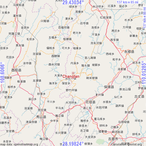
Changtan GPS coordinates[2]
28° 48' 57.996" North, 109° 18' 34.992" East
| Map corner | latitude | longitude |
|---|---|---|
| Upper-left | 29.43034°, | 108.6066° |
| Center: | 28.81611°, | 109.30972° |
| Lower-right: | 28.19824°, | 110.01285° |
| Map W x H: | 137×137 km | = 85.1×85.1mi |
| max Lat: | 53.31946° ⇑67% North |
| Changtan: | 28.81611° |
| min Lat: | ⇓33% South 18.22056° |
| min Long | Changtan | max Long |
| 75.07348° | 109.30972° | 134.28917° |
| W 25.2%⇐ | ⇒74.8% E |
Elevation
Elevation of Changtan is 281 m = 922 ft, and this is 203.8 m = 669 ft below average elevation for this country.
| Max E: |
5622 m = 18445 ft | 38.1% |
| Avg. | 484.8 m = 1591 ft | |
| Changtan | 281 m = 922 ft | |
Min E: |
-3 m = -10 ft | 61.9% |
See also: China elevation on elevation.city.
Geographical zone
Changtan is located in North temperate zone (between Tropic of Cancer and the Arctic Circle). Distance of this Northern Tropic circle is 598.1 km =371.6 mi to South.| Distance of | km | miles | from Changtan |
|---|---|---|---|
| North Pole | 6803 | 4227.2 | to North |
| Arctic Circle | 4197.1 | 2608 | to North |
| Tropic Cancer | 598.1 | 371.6 | to South |
| Equator | 3204.1 | 1990.9 | to South |


Nearby cities:
15 places around Changtan: (largest is in red/bold)
• Bamao
18.3 km =11.4 mi,  107°
107°
• Bamian
9.7 km =6 mi,  326°
326°
• Bao’an
11.6 km =7.2 mi,  213°
213°
• Bi’er
7 km =4.3 mi,  100°
100°
• Daxi
13.9 km =8.6 mi,  263°
263°
• Jiashi
19.5 km =12.1 mi,  27°
27°
• Liren
19.5 km =12.1 mi,  220°
220°
• Liye
3.4 km =2.1 mi, 209°
• Longtou
14.3 km =8.9 mi,  64°
64°
• Mawang
10.1 km =6.3 mi,  118°
118°
• Neixi
10 km =6.2 mi,  8°
8°
• Qingshuiping
5.4 km =3.4 mi, 206°
• Shidi
13.4 km =8.3 mi,  238°
238°
• Yanchong
3.3 km =2.1 mi, 107°
• Yezhuping
15.8 km =9.8 mi,  185°
185°
Sources, notices
• [Note1] Compared only with cities in China existing in our database
• [Src1] Map data: © OpenStreetMap contributors (CC-BY-SA)
• [Src2] Other city data from geonames.org with taken over terms of usage.
• [Src3] Geographical zone / Annual Mean Temperature by Robert A. Rohde @ Wikipedia
