Neixi geodata
Neixi (Hunan) is a seat of a fourth-order administrative division; located in China in Asia/Shanghai (GMT+8) time zone. In our database, there are 1268 cities with bigger population. Compared to other cities in China, 66.3% of cities are located further ↑North; 74.7% of cities are located further →East and 67.3% of cities have lower elevation than Neixi. Note1


Neixi GPS coordinates[2]
28° 54' 17.388" North, 109° 19' 28.2" East
| Map corner | latitude | longitude |
|---|---|---|
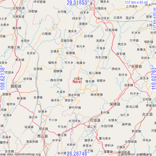
| Upper-left | 29.51853°, | 108.62138° |
| Center: | 28.90483°, | 109.3245° |
| Lower-right: | 28.28748°, | 110.02763° |
| Map W x H: | 136.9×136.9 km | = 85.1×85.1mi |
| max Lat: | 53.31946° ⇑66.3% North |
| Neixi: | 28.90483° |
| min Lat: | ⇓33.7% South 18.22056° |
| min Long | Neixi | max Long |
| 75.07348° | 109.3245° | 134.28917° |
| W 25.3%⇐ | ⇒74.7% E |
Elevation
Elevation of Neixi is 364 m = 1194 ft, and this is 120.8 m = 396 ft below average elevation for this country.
| Max E: |
5622 m = 18445 ft | 32.7% |
| Avg. | 484.8 m = 1591 ft | |
| Neixi | 364 m = 1194 ft | |
Min E: |
-3 m = -10 ft | 67.3% |
See also: China elevation on elevation.city.
Geographical zone
Neixi is located in North temperate zone (between Tropic of Cancer and the Arctic Circle). Distance of this Northern Tropic circle is 608 km =377.8 mi to South.| Distance of | km | miles | from Neixi |
|---|---|---|---|
| North Pole | 6793.1 | 4221 | to North |
| Arctic Circle | 4187.3 | 2601.9 | to North |
| Tropic Cancer | 608 | 377.8 | to South |
| Equator | 3213.9 | 1997 | to South |


Nearby cities:
15 places around Neixi: (largest is in red/bold)
• Bamian
7.1 km =4.4 mi,  254°
254°
• Bi’er
12.4 km =7.7 mi,  153°
153°
• Changtan
10 km =6.2 mi,  188°
188°
• Daxi
19 km =11.8 mi,  233°
233°
• Fengxizhai
16.4 km =10.2 mi,  46°
46°
• Jiashi
10.6 km =6.6 mi, 45°
• Keda
16 km =9.9 mi,  329°
329°
• Liye
13.2 km =8.2 mi, 193°
• Longtou
12.1 km =7.5 mi,  108°
108°
• Mawang
16.5 km =10.3 mi, 153°
• Miao’ertan
15.3 km =9.5 mi,  70°
70°
• Qingshuiping
15.2 km =9.4 mi, 194°
• Yanchong
11 km =6.8 mi,  171°
171°
• Youchou
19 km =11.8 mi,  290°
290°
• Zanguoping
13.7 km =8.5 mi,  9°
9°
Sources, notices
• [Note1] Compared only with cities in China existing in our database
• [Src1] Map data: © OpenStreetMap contributors (CC-BY-SA)
• [Src2] Other city data from geonames.org with taken over terms of usage.
• [Src3] Geographical zone / Annual Mean Temperature by Robert A. Rohde @ Wikipedia
