Bi’er geodata
Bi’er (Hunan) is a seat of a fourth-order administrative division; located in China in Asia/Shanghai (GMT+8) time zone. In our database, there are 1268 cities with bigger population. Compared to other cities in China, 67.1% of cities are located further ↑North; 74.5% of cities are located further →East and 61.7% of cities have lower elevation than Bi’er. Note1


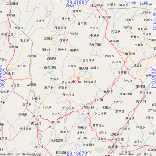
Bi’er GPS coordinates[2]
28° 48' 17.028" North, 109° 22' 50.412" East
| Map corner | latitude | longitude |
|---|---|---|
| Upper-left | 29.41903°, | 108.67755° |
| Center: | 28.80473°, | 109.38067° |
| Lower-right: | 28.18679°, | 110.0838° |
| Map W x H: | 137×137 km | = 85.1×85.1mi |
| max Lat: | 53.31946° ⇑67.1% North |
| Bi’er: | 28.80473° |
| min Lat: | ⇓32.9% South 18.22056° |
| min Long | Bi’er | max Long |
| 75.07348° | 109.38067° | 134.28917° |
| W 25.5%⇐ | ⇒74.5% E |
Elevation
Elevation of Bi’er is 279 m = 915 ft, and this is 205.8 m = 675 ft below average elevation for this country.
| Max E: |
5622 m = 18445 ft | 38.3% |
| Avg. | 484.8 m = 1591 ft | |
| Bi’er | 279 m = 915 ft | |
Min E: |
-3 m = -10 ft | 61.7% |
See also: China elevation on elevation.city.
Geographical zone
Bi’er is located in North temperate zone (between Tropic of Cancer and the Arctic Circle). Distance of this Northern Tropic circle is 596.9 km =370.9 mi to South.| Distance of | km | miles | from Bi’er |
|---|---|---|---|
| North Pole | 6804.3 | 4228 | to North |
| Arctic Circle | 4198.4 | 2608.8 | to North |
| Tropic Cancer | 596.9 | 370.9 | to South |
| Equator | 3202.8 | 1990.1 | to South |


Nearby cities:
15 places around Bi’er: (largest is in red/bold)
• Bamao
11.4 km =7.1 mi,  111°
111°
• Bamian
15.4 km =9.6 mi,  307°
307°
• Bao’an
15.8 km =9.8 mi,  238°
238°
• Changtan
7 km =4.3 mi,  280°
280°
• Datuo
16.6 km =10.3 mi,  149°
149°
• Jiashi
18.7 km =11.6 mi,  6°
6°
• Liye
8.8 km =5.5 mi,  258°
258°
• Longtou
9.5 km =5.9 mi,  39°
39°
• Mawang
4.1 km =2.5 mi, 150°
• Miao’ertan
18.5 km =11.5 mi,  29°
29°
• Neixi
12.4 km =7.7 mi,  333°
333°
• Pojiao
17.5 km =10.9 mi,  57°
57°
• Qingshuiping
10 km =6.2 mi,  249°
249°
• Yanchong
3.8 km =2.4 mi,  274°
274°
• Yezhuping
16.7 km =10.4 mi,  210°
210°
Sources, notices
• [Note1] Compared only with cities in China existing in our database
• [Src1] Map data: © OpenStreetMap contributors (CC-BY-SA)
• [Src2] Other city data from geonames.org with taken over terms of usage.
• [Src3] Geographical zone / Annual Mean Temperature by Robert A. Rohde @ Wikipedia
