Deshan geodata
Deshan (Hunan) is a seat of a fourth-order administrative division; located in China in Asia/Shanghai (GMT+8) time zone. In our database, there are 1268 cities with bigger population. Compared to other cities in China, 66.1% of cities are located further ↑North; 63.9% of cities are located further →East and 74.1% of cities have higher elevation than Deshan. Note1


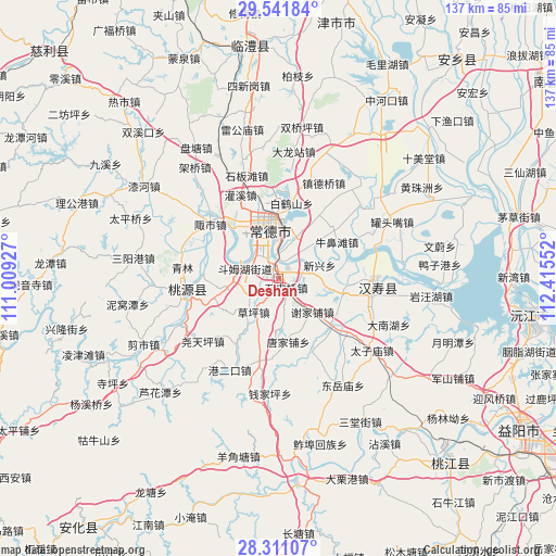
Deshan GPS coordinates[2]
28° 55' 41.808" North, 111° 42' 44.604" East
| Map corner | latitude | longitude |
|---|---|---|
| Upper-left | 29.54184°, | 111.00927° |
| Center: | 28.92828°, | 111.71239° |
| Lower-right: | 28.31107°, | 112.41552° |
| Map W x H: | 136.8×136.8 km | = 85×85mi |
| max Lat: | 53.31946° ⇑66.1% North |
| Deshan: | 28.92828° |
| min Lat: | ⇓33.9% South 18.22056° |
| min Long | Deshan | max Long |
| 75.07348° | 111.71239° | 134.28917° |
| W 36.1%⇐ | ⇒63.9% E |
Elevation
Elevation of Deshan is 39 m = 128 ft, and this is 445.8 m = 1463 ft below average elevation for this country.
| Max E: |
5622 m = 18445 ft | 74.1% |
| Avg. | 484.8 m = 1591 ft | |
| Deshan | 39 m = 128 ft | |
Min E: |
-3 m = -10 ft | 25.9% |
See also: China elevation on elevation.city.
Geographical zone
Deshan is located in North temperate zone (between Tropic of Cancer and the Arctic Circle). Distance of this Northern Tropic circle is 610.6 km =379.4 mi to South.| Distance of | km | miles | from Deshan |
|---|---|---|---|
| North Pole | 6790.5 | 4219.4 | to North |
| Arctic Circle | 4184.7 | 2600.3 | to North |
| Tropic Cancer | 610.6 | 379.4 | to South |
| Equator | 3216.5 | 1998.6 | to South |


Nearby cities:
15 places around Deshan: (largest is in red/bold)
• Changde
13.5 km =8.4 mi,  345°
345°
• Danzhou
11.8 km =7.3 mi,  320°
320°
• Dingcheng
10.6 km =6.6 mi,  342°
342°
• Dingjiagang
15.8 km =9.8 mi,  250°
250°
• Dongjiang
12.2 km =7.6 mi,  15°
15°
• Dongjiao
10.3 km =6.4 mi,  358°
358°
• Doumuhu
8.5 km =5.3 mi,  285°
285°
• Hucheng
12.9 km =8 mi, 348°
• Hucheng
14 km =8.7 mi, 338°
• Ludishan
8.8 km =5.5 mi,  14°
14°
• Nanpinggang
15.5 km =9.6 mi, 350°
• Shimenqiao
3.4 km =2.1 mi,  138°
138°
• Xiejiapu
13.6 km =8.5 mi, 141°
• Xinxing
11.3 km =7 mi,  73°
73°
• Xujiaqiao
12.5 km =7.8 mi,  262°
262°
Sources, notices
• [Note1] Compared only with cities in China existing in our database
• [Src1] Map data: © OpenStreetMap contributors (CC-BY-SA)
• [Src2] Other city data from geonames.org with taken over terms of usage.
• [Src3] Geographical zone / Annual Mean Temperature by Robert A. Rohde @ Wikipedia
