Lidun geodata
Lidun (Fujian) is a seat of a fourth-order administrative division; located in China in Asia/Shanghai (GMT+8) time zone. In our database, there are 1268 cities with bigger population. Compared to other cities in China, 78.4% of cities are located further ↑North; 77.4% of cities are located further ←West and 83.6% of cities have lower elevation than Lidun. Note1


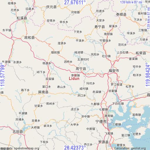
Lidun GPS coordinates[2]
27° 3' 6.012" North, 119° 16' 51.996" East
| Map corner | latitude | longitude |
|---|---|---|
| Upper-left | 27.67611°, | 118.57799° |
| Center: | 27.05167°, | 119.28111° |
| Lower-right: | 26.42373°, | 119.98424° |
| Map W x H: | 139.3×139.3 km | = 86.6×86.6mi |
| max Lat: | 53.31946° ⇑78.4% North |
| Lidun: | 27.05167° |
| min Lat: | ⇓21.6% South 18.22056° |
| min Long | Lidun | max Long |
| 75.07348° | 119.28111° | 134.28917° |
| W 77.4%⇐ | ⇒22.6% E |
Elevation
Elevation of Lidun is 893 m = 2930 ft, and this is 408.2 m = 1339 ft above average elevation for this country.
| Max E: |
5622 m = 18445 ft | 16.4% |
| Lidun | 893 m 2930 ft | |
| Avg. | 484.8 m = 1591 ft | |
Min E: |
-3 m = -10 ft | 83.6% |
See also: China elevation on elevation.city.
Geographical zone
Lidun is located in North temperate zone (between Tropic of Cancer and the Arctic Circle). Distance of this Northern Tropic circle is 401.9 km =249.7 mi to South.| Distance of | km | miles | from Lidun |
|---|---|---|---|
| North Pole | 6999.2 | 4349.1 | to North |
| Arctic Circle | 4393.3 | 2729.9 | to North |
| Tropic Cancer | 401.9 | 249.7 | to South |
| Equator | 3007.9 | 1869 | to South |


Nearby cities:
15 places around Lidun: (largest is in red/bold)
• Chixi
25.4 km =15.8 mi,  127°
127°
• Chunchi
21.6 km =13.4 mi,  8°
8°
• Huotong
26.2 km =16.3 mi,  148°
148°
• Kangcuo
24.8 km =15.4 mi,  89°
89°
• Limen
7.1 km =4.4 mi,  264°
264°
• Muyang
23.8 km =14.8 mi, 87°
• Muyun
25.8 km =16 mi, 87°
• Puyuan
8.1 km =5 mi, 9°
• Qibu
6.7 km =4.2 mi,  65°
65°
• Shoushan
15.3 km =9.5 mi,  230°
230°
• Shuangxi
24 km =14.9 mi, 262°
• Siqiao
14.2 km =8.8 mi,  332°
332°
• Xiancun
14.8 km =9.2 mi, 148°
• Xiaoyang
22.6 km =14 mi,  48°
48°
• Zhouning
8.1 km =5 mi,  41°
41°
Sources, notices
• [Note1] Compared only with cities in China existing in our database
• [Src1] Map data: © OpenStreetMap contributors (CC-BY-SA)
• [Src2] Other city data from geonames.org with taken over terms of usage.
• [Src3] Geographical zone / Annual Mean Temperature by Robert A. Rohde @ Wikipedia
