Xinfeng geodata
Xinfeng (Shaanxi) is a seat of a fourth-order administrative division; located in China in Asia/Shanghai (GMT+8) time zone. In our database, there are 1268 cities with bigger population. Compared to other cities in China, 72.3% of cities are located further ↓South; 75.1% of cities are located further →East and 68.7% of cities have lower elevation than Xinfeng. Note1


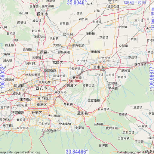
Xinfeng GPS coordinates[2]
34° 25' 35.904" North, 109° 15' 49.104" East
| Map corner | latitude | longitude |
|---|---|---|
| Upper-left | 35.0046°, | 108.56052° |
| Center: | 34.42664°, | 109.26364° |
| Lower-right: | 33.84466°, | 109.96677° |
| Map W x H: | 129×129 km | = 80.2×80.2mi |
| max Lat: | 53.31946° ⇑27.7% North |
| Xinfeng: | 34.42664° |
| min Lat: | ⇓72.3% South 18.22056° |
| min Long | Xinfeng | max Long |
| 75.07348° | 109.26364° | 134.28917° |
| W 24.9%⇐ | ⇒75.1% E |
Elevation
Elevation of Xinfeng is 389 m = 1276 ft, and this is 95.8 m = 314 ft below average elevation for this country.
| Max E: |
5622 m = 18445 ft | 31.3% |
| Avg. | 484.8 m = 1591 ft | |
| Xinfeng | 389 m = 1276 ft | |
Min E: |
-3 m = -10 ft | 68.7% |
See also: China elevation on elevation.city.
Geographical zone
Xinfeng is located in North temperate zone (between Tropic of Cancer and the Arctic Circle). Distance of this Northern Tropic circle is 1222 km =759.3 mi to South.| Distance of | km | miles | from Xinfeng |
|---|---|---|---|
| North Pole | 6179.2 | 3839.6 | to North |
| Arctic Circle | 3573.3 | 2220.3 | to North |
| Tropic Cancer | 1222 | 759.3 | to South |
| Equator | 3827.9 | 2378.5 | to South |


Nearby cities:
15 places around Xinfeng: (largest is in red/bold)
• Daiwang
4.3 km =2.7 mi,  139°
139°
• Hezhai
11.2 km =7 mi,  26°
26°
• Jiaokou
14.1 km =8.8 mi,  12°
12°
• Lingkou
10.6 km =6.6 mi,  57°
57°
• Lintong
7.4 km =4.6 mi,  222°
222°
• Ma’e
11.4 km =7.1 mi,  103°
103°
• Muzhai
11.7 km =7.3 mi,  125°
125°
• Qinling Jieban
4.6 km =2.9 mi,  196°
196°
• Renliu
7.8 km =4.8 mi,  334°
334°
• Tuqiao
9.8 km =6.1 mi,  148°
148°
• Xiekou
12.5 km =7.8 mi,  234°
234°
• Xingzhe
6.6 km =4.1 mi,  248°
248°
• Xinshi
14.6 km =9.1 mi, 328°
• Xiquan
11.7 km =7.3 mi,  259°
259°
• Yujin
10 km =6.2 mi,  349°
349°
Sources, notices
• [Note1] Compared only with cities in China existing in our database
• [Src1] Map data: © OpenStreetMap contributors (CC-BY-SA)
• [Src2] Other city data from geonames.org with taken over terms of usage.
• [Src3] Geographical zone / Annual Mean Temperature by Robert A. Rohde @ Wikipedia
