Longquan geodata
Longquan (Shaanxi) is a seat of a fourth-order administrative division; located in China in Asia/Shanghai (GMT+8) time zone. In our database, there are 1268 cities with bigger population. Compared to other cities in China, 73.7% of cities are located further ↓South; 76.9% of cities are located further →East and 72% of cities have lower elevation than Longquan. Note1


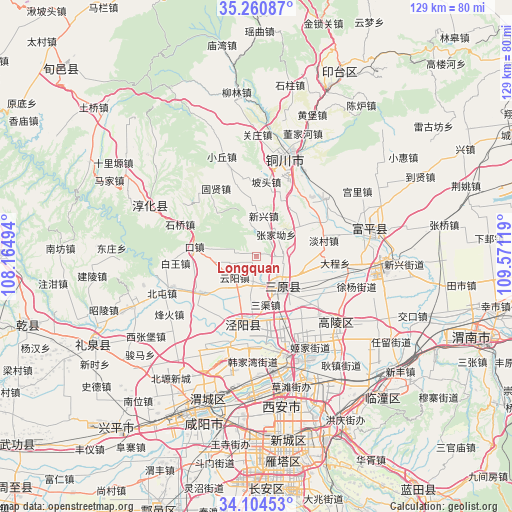
Longquan GPS coordinates[2]
34° 41' 4.992" North, 108° 52' 5.016" East
| Map corner | latitude | longitude |
|---|---|---|
| Upper-left | 35.26087°, | 108.16494° |
| Center: | 34.68472°, | 108.86806° |
| Lower-right: | 34.10453°, | 109.57119° |
| Map W x H: | 128.6×128.6 km | = 79.9×79.9mi |
| max Lat: | 53.31946° ⇑26.3% North |
| Longquan: | 34.68472° |
| min Lat: | ⇓73.7% South 18.22056° |
| min Long | Longquan | max Long |
| 75.07348° | 108.86806° | 134.28917° |
| W 23.1%⇐ | ⇒76.9% E |
Elevation
Elevation of Longquan is 453 m = 1486 ft, and this is 31.8 m = 104 ft below average elevation for this country.
| Max E: |
5622 m = 18445 ft | 28% |
| Avg. | 484.8 m = 1591 ft | |
| Longquan | 453 m = 1486 ft | |
Min E: |
-3 m = -10 ft | 72% |
See also: China elevation on elevation.city.
Geographical zone
Longquan is located in North temperate zone (between Tropic of Cancer and the Arctic Circle). Distance of this Northern Tropic circle is 1250.7 km =777.1 mi to South.| Distance of | km | miles | from Longquan |
|---|---|---|---|
| North Pole | 6150.5 | 3821.7 | to North |
| Arctic Circle | 3544.6 | 2202.5 | to North |
| Tropic Cancer | 1250.7 | 777.1 | to South |
| Equator | 3856.6 | 2396.4 | to South |


Nearby cities:
15 places around Longquan: (largest is in red/bold)
• Anle
16.8 km =10.4 mi,  125°
125°
• Cuo’e
6.1 km =3.8 mi,  9°
9°
• Kouzhen
15.8 km =9.8 mi,  279°
279°
• Lingqian
13.5 km =8.4 mi,  51°
51°
• Luqiao
4.5 km =2.8 mi,  89°
89°
• Ma’e
16.5 km =10.3 mi,  20°
20°
• Qiaodi
16.4 km =10.2 mi,  237°
237°
• Sanqu
12.5 km =7.8 mi,  169°
169°
• Sanyuan Chengguanzhen
9.5 km =5.9 mi,  144°
144°
• Xinglong
16.5 km =10.3 mi,  255°
255°
• Xinxing
10.2 km =6.3 mi, 8°
• Xiyang
13.1 km =8.1 mi,  101°
101°
• Yanwang
13.9 km =8.6 mi,  205°
205°
• Yunyang
7.6 km =4.7 mi,  225°
225°
• Zhongzhang
17.2 km =10.7 mi, 212°
Sources, notices
• [Note1] Compared only with cities in China existing in our database
• [Src1] Map data: © OpenStreetMap contributors (CC-BY-SA)
• [Src2] Other city data from geonames.org with taken over terms of usage.
• [Src3] Geographical zone / Annual Mean Temperature by Robert A. Rohde @ Wikipedia
