Cuo’e geodata
Cuo’e (Shaanxi) is a seat of a fourth-order administrative division; located in China in Asia/Shanghai (GMT+8) time zone. In our database, there are 1268 cities with bigger population. Compared to other cities in China, 74% of cities are located further ↓South; 76.9% of cities are located further →East and 75.8% of cities have lower elevation than Cuo’e. Note1


Cuo’e GPS coordinates[2]
34° 44' 21.012" North, 108° 52' 44.004" East
| Map corner | latitude | longitude |
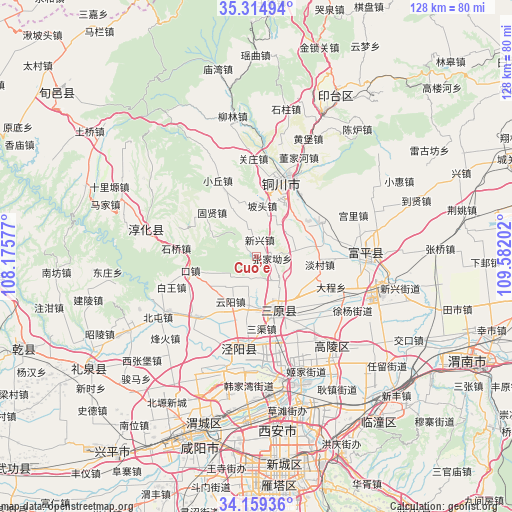
|---|---|---|
| Upper-left | 35.31494°, | 108.17577° |
| Center: | 34.73917°, | 108.87889° |
| Lower-right: | 34.15936°, | 109.58202° |
| Map W x H: | 128.5×128.5 km | = 79.8×79.8mi |
| max Lat: | 53.31946° ⇑26% North |
| Cuo’e: | 34.73917° |
| min Lat: | ⇓74% South 18.22056° |
| min Long | Cuo’e | max Long |
| 75.07348° | 108.87889° | 134.28917° |
| W 23.1%⇐ | ⇒76.9% E |
Elevation
Elevation of Cuo’e is 541 m = 1775 ft, and this is 56.2 m = 184 ft above average elevation for this country.
| Max E: |
5622 m = 18445 ft | 24.2% |
| Cuo’e | 541 m 1775 ft | |
| Avg. | 484.8 m = 1591 ft | |
Min E: |
-3 m = -10 ft | 75.8% |
See also: China elevation on elevation.city.
Geographical zone
Cuo’e is located in North temperate zone (between Tropic of Cancer and the Arctic Circle). Distance of this Northern Tropic circle is 1256.7 km =780.9 mi to South.| Distance of | km | miles | from Cuo’e |
|---|---|---|---|
| North Pole | 6144.4 | 3818 | to North |
| Arctic Circle | 3538.5 | 2198.7 | to North |
| Tropic Cancer | 1256.7 | 780.9 | to South |
| Equator | 3862.6 | 2400.1 | to South |


Nearby cities:
15 places around Cuo’e: (largest is in red/bold)
• Dancun
16.1 km =10 mi,  97°
97°
• Fangli
16 km =9.9 mi,  305°
305°
• Guxian
15.7 km =9.8 mi, 314°
• Kouzhen
16.9 km =10.5 mi,  258°
258°
• Lingqian
9.9 km =6.2 mi,  76°
76°
• Longquan
6.1 km =3.8 mi,  189°
189°
• Luqiao
7 km =4.3 mi,  149°
149°
• Ma’e
10.6 km =6.6 mi,  26°
26°
• Meijiaping
17.5 km =10.9 mi,  36°
36°
• Mizi
14.9 km =9.3 mi,  56°
56°
• Potou
12.7 km =7.9 mi,  6°
6°
• Sanyuan Chengguanzhen
14.6 km =9.1 mi,  161°
161°
• Xinxing
4.1 km =2.5 mi, 7°
• Xiyang
14.7 km =9.1 mi,  126°
126°
• Yunyang
13 km =8.1 mi,  209°
209°
Sources, notices
• [Note1] Compared only with cities in China existing in our database
• [Src1] Map data: © OpenStreetMap contributors (CC-BY-SA)
• [Src2] Other city data from geonames.org with taken over terms of usage.
• [Src3] Geographical zone / Annual Mean Temperature by Robert A. Rohde @ Wikipedia
