Kouzhen geodata
Kouzhen (Shaanxi) is a seat of a fourth-order administrative division; located in China in Asia/Shanghai (GMT+8) time zone. In our database, there are 1268 cities with bigger population. Compared to other cities in China, 73.8% of cities are located further ↓South; 77.7% of cities are located further →East and 78.1% of cities have lower elevation than Kouzhen. Note1


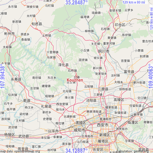
Kouzhen GPS coordinates[2]
34° 42' 32.004" North, 108° 41' 51" East
| Map corner | latitude | longitude |
|---|---|---|
| Upper-left | 35.28487°, | 107.99438° |
| Center: | 34.70889°, | 108.6975° |
| Lower-right: | 34.12887°, | 109.40063° |
| Map W x H: | 128.5×128.5 km | = 79.8×79.8mi |
| max Lat: | 53.31946° ⇑26.2% North |
| Kouzhen: | 34.70889° |
| min Lat: | ⇓73.8% South 18.22056° |
| min Long | Kouzhen | max Long |
| 75.07348° | 108.6975° | 134.28917° |
| W 22.3%⇐ | ⇒77.7% E |
Elevation
Elevation of Kouzhen is 620 m = 2034 ft, and this is 135.2 m = 444 ft above average elevation for this country.
| Max E: |
5622 m = 18445 ft | 21.9% |
| Kouzhen | 620 m 2034 ft | |
| Avg. | 484.8 m = 1591 ft | |
Min E: |
-3 m = -10 ft | 78.1% |
See also: China elevation on elevation.city.
Geographical zone
Kouzhen is located in North temperate zone (between Tropic of Cancer and the Arctic Circle). Distance of this Northern Tropic circle is 1253.3 km =778.8 mi to South.| Distance of | km | miles | from Kouzhen |
|---|---|---|---|
| North Pole | 6147.8 | 3820.1 | to North |
| Arctic Circle | 3541.9 | 2200.8 | to North |
| Tropic Cancer | 1253.3 | 778.8 | to South |
| Equator | 3859.3 | 2398.1 | to South |


Nearby cities:
15 places around Kouzhen: (largest is in red/bold)
• Baiwang
5.9 km =3.7 mi,  228°
228°
• Chunhua
15 km =9.3 mi,  311°
311°
• Cuo’e
16.9 km =10.5 mi,  78°
78°
• Dadian
10.9 km =6.8 mi, 312°
• Fangli
13.2 km =8.2 mi,  15°
15°
• Fenghuo
18.4 km =11.4 mi,  200°
200°
• Guxian
15.4 km =9.6 mi, 20°
• Longquan
15.8 km =9.8 mi,  99°
99°
• Qiaodi
11.5 km =7.1 mi,  171°
171°
• Shiqiao
6.5 km =4 mi,  327°
327°
• Wangqiao
11.5 km =7.1 mi,  206°
206°
• Xinglong
6.8 km =4.2 mi,  183°
183°
• Yanwang
18 km =11.2 mi,  147°
147°
• Yunyang
12.9 km =8 mi,  128°
128°
• Zhongzhang
18.3 km =11.4 mi,  159°
159°
Sources, notices
• [Note1] Compared only with cities in China existing in our database
• [Src1] Map data: © OpenStreetMap contributors (CC-BY-SA)
• [Src2] Other city data from geonames.org with taken over terms of usage.
• [Src3] Geographical zone / Annual Mean Temperature by Robert A. Rohde @ Wikipedia
