Shangyi geodata
Shangyi (Shaanxi) is a seat of a fourth-order administrative division; located in China in Asia/Shanghai (GMT+8) time zone. In our database, there are 1268 cities with bigger population. Compared to other cities in China, 74.4% of cities are located further ↓South; 79.6% of cities are located further →East and 86.6% of cities have lower elevation than Shangyi. Note1


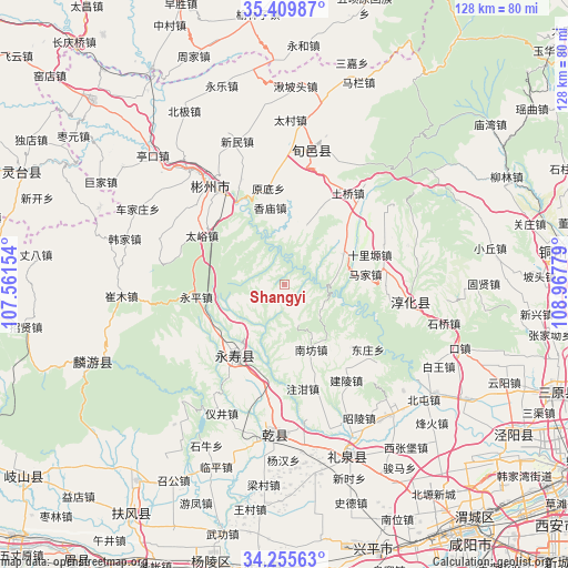
Shangyi GPS coordinates[2]
34° 50' 5.172" North, 108° 15' 52.776" East
| Map corner | latitude | longitude |
|---|---|---|
| Upper-left | 35.40987°, | 107.56154° |
| Center: | 34.83477°, | 108.26466° |
| Lower-right: | 34.25563°, | 108.96779° |
| Map W x H: | 128.3×128.3 km | = 79.7×79.7mi |
| max Lat: | 53.31946° ⇑25.6% North |
| Shangyi: | 34.83477° |
| min Lat: | ⇓74.4% South 18.22056° |
| min Long | Shangyi | max Long |
| 75.07348° | 108.26466° | 134.28917° |
| W 20.4%⇐ | ⇒79.6% E |
Elevation
Elevation of Shangyi is 1092 m = 3583 ft, and this is 607.2 m = 1992 ft above average elevation for this country.
| Max E: |
5622 m = 18445 ft | 13.4% |
| Shangyi | 1092 m 3583 ft | |
| Avg. | 484.8 m = 1591 ft | |
Min E: |
-3 m = -10 ft | 86.6% |
See also: China elevation on elevation.city.
Geographical zone
Shangyi is located in North temperate zone (between Tropic of Cancer and the Arctic Circle). Distance of this Northern Tropic circle is 1267.3 km =787.5 mi to South.| Distance of | km | miles | from Shangyi |
|---|---|---|---|
| North Pole | 6133.8 | 3811.4 | to North |
| Arctic Circle | 3527.9 | 2192.1 | to North |
| Tropic Cancer | 1267.3 | 787.5 | to South |
| Equator | 3873.3 | 2406.8 | to South |


Nearby cities:
15 places around Shangyi: (largest is in red/bold)
• Changning
1.4 km =0.9 mi,  251°
251°
• Doujia
5.3 km =3.3 mi,  142°
142°
• Duma
14.1 km =8.8 mi,  236°
236°
• Fengyang
16.9 km =10.5 mi,  176°
176°
• Guanzhuang
15.2 km =9.4 mi,  61°
61°
• Hujiamiao
19.6 km =12.2 mi,  45°
45°
• Jianjun
19.6 km =12.2 mi,  215°
215°
• Longgao
14.2 km =8.8 mi,  18°
18°
• Mafang
10.8 km =6.7 mi, 239°
• Majia
17.9 km =11.1 mi,  81°
81°
• Nanfang
15.4 km =9.6 mi,  155°
155°
• Quzi
7.8 km =4.8 mi,  296°
296°
• Xiangmiao
17.9 km =11.1 mi,  348°
348°
• Yongtai
12.1 km =7.5 mi, 300°
• Yujiagong
13.7 km =8.5 mi,  210°
210°
Sources, notices
• [Note1] Compared only with cities in China existing in our database
• [Src1] Map data: © OpenStreetMap contributors (CC-BY-SA)
• [Src2] Other city data from geonames.org with taken over terms of usage.
• [Src3] Geographical zone / Annual Mean Temperature by Robert A. Rohde @ Wikipedia
