Xiaohui geodata
Xiaohui (Shaanxi) is a seat of a fourth-order administrative division; located in China in Asia/Shanghai (GMT+8) time zone. In our database, there are 1268 cities with bigger population. Compared to other cities in China, 74.7% of cities are located further ↓South; 75% of cities are located further →East and 75% of cities have lower elevation than Xiaohui. Note1


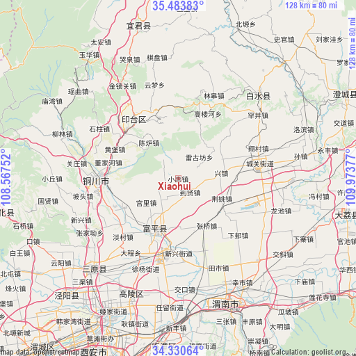
Xiaohui GPS coordinates[2]
34° 54' 33.336" North, 109° 16' 14.304" East
| Map corner | latitude | longitude |
|---|---|---|
| Upper-left | 35.48383°, | 108.56752° |
| Center: | 34.90926°, | 109.27064° |
| Lower-right: | 34.33064°, | 109.97377° |
| Map W x H: | 128.2×128.2 km | = 79.7×79.7mi |
| max Lat: | 53.31946° ⇑25.3% North |
| Xiaohui: | 34.90926° |
| min Lat: | ⇓74.7% South 18.22056° |
| min Long | Xiaohui | max Long |
| 75.07348° | 109.27064° | 134.28917° |
| W 25%⇐ | ⇒75% E |
Elevation
Elevation of Xiaohui is 522 m = 1713 ft, and this is 37.2 m = 122 ft above average elevation for this country.
| Max E: |
5622 m = 18445 ft | 25% |
| Xiaohui | 522 m 1713 ft | |
| Avg. | 484.8 m = 1591 ft | |
Min E: |
-3 m = -10 ft | 75% |
See also: China elevation on elevation.city.
Geographical zone
Xiaohui is located in North temperate zone (between Tropic of Cancer and the Arctic Circle). Distance of this Northern Tropic circle is 1275.6 km =792.6 mi to South.| Distance of | km | miles | from Xiaohui |
|---|---|---|---|
| North Pole | 6125.5 | 3806.2 | to North |
| Arctic Circle | 3519.6 | 2187 | to North |
| Tropic Cancer | 1275.6 | 792.6 | to South |
| Equator | 3881.5 | 2411.9 | to South |


Nearby cities:
15 places around Xiaohui: (largest is in red/bold)
• Baimiao
12 km =7.5 mi,  285°
285°
• Caocun
6.4 km =4 mi,  260°
260°
• Daoxian
6.8 km =4.2 mi,  143°
143°
• Didian
9.7 km =6 mi,  330°
330°
• Gongli
14.4 km =8.9 mi,  233°
233°
• Huazhu
15.3 km =9.5 mi,  206°
206°
• Jingyao
17.3 km =10.7 mi,  114°
114°
• Liuji
15.5 km =9.6 mi,  167°
167°
• Liuqu
4.8 km =3 mi,  185°
185°
• Meiyuan
8.5 km =5.3 mi,  62°
62°
• Shijia
14.5 km =9 mi,  134°
134°
• Sufang
9.3 km =5.8 mi,  99°
99°
• Wangliao
11.8 km =7.3 mi,  197°
197°
• Xingzhen
16.4 km =10.2 mi,  81°
81°
• Xuezhen
5.6 km =3.5 mi,  25°
25°
Sources, notices
• [Note1] Compared only with cities in China existing in our database
• [Src1] Map data: © OpenStreetMap contributors (CC-BY-SA)
• [Src2] Other city data from geonames.org with taken over terms of usage.
• [Src3] Geographical zone / Annual Mean Temperature by Robert A. Rohde @ Wikipedia
