Baimiao geodata
Baimiao (Shaanxi) is a seat of a fourth-order administrative division; located in China in Asia/Shanghai (GMT+8) time zone. In our database, there are 1268 cities with bigger population. Compared to other cities in China, 74.8% of cities are located further ↓South; 75.6% of cities are located further →East and 87.4% of cities have lower elevation than Baimiao. Note1


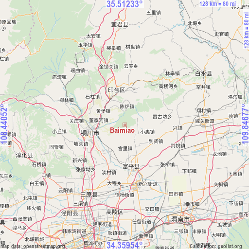
Baimiao GPS coordinates[2]
34° 56' 16.656" North, 109° 8' 37.104" East
| Map corner | latitude | longitude |
|---|---|---|
| Upper-left | 35.51233°, | 108.44052° |
| Center: | 34.93796°, | 109.14364° |
| Lower-right: | 34.35954°, | 109.84677° |
| Map W x H: | 128.2×128.2 km | = 79.7×79.7mi |
| max Lat: | 53.31946° ⇑25.2% North |
| Baimiao: | 34.93796° |
| min Lat: | ⇓74.8% South 18.22056° |
| min Long | Baimiao | max Long |
| 75.07348° | 109.14364° | 134.28917° |
| W 24.4%⇐ | ⇒75.6% E |
Elevation
Elevation of Baimiao is 1140 m = 3740 ft, and this is 655.2 m = 2150 ft above average elevation for this country.
| Max E: |
5622 m = 18445 ft | 12.6% |
| Baimiao | 1140 m 3740 ft | |
| Avg. | 484.8 m = 1591 ft | |
Min E: |
-3 m = -10 ft | 87.4% |
See also: China elevation on elevation.city.
Geographical zone
Baimiao is located in North temperate zone (between Tropic of Cancer and the Arctic Circle). Distance of this Northern Tropic circle is 1278.8 km =794.6 mi to South.| Distance of | km | miles | from Baimiao |
|---|---|---|---|
| North Pole | 6122.3 | 3804.2 | to North |
| Arctic Circle | 3516.4 | 2185 | to North |
| Tropic Cancer | 1278.8 | 794.6 | to South |
| Equator | 3884.7 | 2413.8 | to South |


Nearby cities:
15 places around Baimiao: (largest is in red/bold)
• Caocun
6.7 km =4.2 mi,  128°
128°
• Didian
8.6 km =5.3 mi,  52°
52°
• Dongjiahe
13.6 km =8.5 mi,  281°
281°
• Gongli
11.9 km =7.4 mi,  179°
179°
• Huangbao
13.1 km =8.1 mi,  304°
304°
• Liuqu
13.7 km =8.5 mi, 125°
• Meijiaping
15.9 km =9.9 mi,  239°
239°
• Qicun
13.2 km =8.2 mi,  193°
193°
• Sunyuan
10.8 km =6.7 mi,  273°
273°
• Tongchuanshi
16.1 km =10 mi,  340°
340°
• Wangliao
16.6 km =10.3 mi,  150°
150°
• Xiaohui
12 km =7.5 mi,  105°
105°
• Xuezhen
14.1 km =8.8 mi,  82°
82°
• Yaozhou
16.2 km =10.1 mi,  257°
257°
• Zhuangli
15.2 km =9.4 mi,  210°
210°
Sources, notices
• [Note1] Compared only with cities in China existing in our database
• [Src1] Map data: © OpenStreetMap contributors (CC-BY-SA)
• [Src2] Other city data from geonames.org with taken over terms of usage.
• [Src3] Geographical zone / Annual Mean Temperature by Robert A. Rohde @ Wikipedia
