Sufang geodata
Sufang (Shaanxi) is a seat of a fourth-order administrative division; located in China in Asia/Shanghai (GMT+8) time zone. In our database, there are 1268 cities with bigger population. Compared to other cities in China, 72.1% of cities are located further ↓South; 80.3% of cities are located further →East and 76.4% of cities have lower elevation than Sufang. Note1


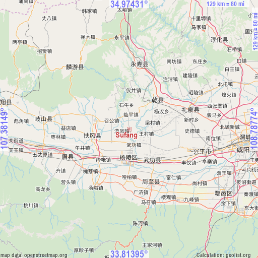
Sufang GPS coordinates[2]
34° 23' 46.104" North, 108° 5' 4.596" East
| Map corner | latitude | longitude |
|---|---|---|
| Upper-left | 34.97431°, | 107.38149° |
| Center: | 34.39614°, | 108.08461° |
| Lower-right: | 33.81395°, | 108.78774° |
| Map W x H: | 129×129 km | = 80.2×80.2mi |
| max Lat: | 53.31946° ⇑27.9% North |
| Sufang: | 34.39614° |
| min Lat: | ⇓72.1% South 18.22056° |
| min Long | Sufang | max Long |
| 75.07348° | 108.08461° | 134.28917° |
| W 19.7%⇐ | ⇒80.3% E |
Elevation
Elevation of Sufang is 556 m = 1824 ft, and this is 71.2 m = 234 ft above average elevation for this country.
| Max E: |
5622 m = 18445 ft | 23.6% |
| Sufang | 556 m 1824 ft | |
| Avg. | 484.8 m = 1591 ft | |
Min E: |
-3 m = -10 ft | 76.4% |
See also: China elevation on elevation.city.
Geographical zone
Sufang is located in North temperate zone (between Tropic of Cancer and the Arctic Circle). Distance of this Northern Tropic circle is 1218.6 km =757.2 mi to South.| Distance of | km | miles | from Sufang |
|---|---|---|---|
| North Pole | 6182.6 | 3841.7 | to North |
| Arctic Circle | 3576.7 | 2222.5 | to North |
| Tropic Cancer | 1218.6 | 757.2 | to South |
| Equator | 3824.5 | 2376.4 | to South |


Nearby cities:
15 places around Sufang: (largest is in red/bold)
• Daijia
9.1 km =5.7 mi,  138°
138°
• Jiangcun
15.4 km =9.6 mi,  91°
91°
• Linping
7.7 km =4.8 mi,  8°
8°
• Shiniu
12.4 km =7.7 mi,  354°
354°
• Taibai
11.8 km =7.3 mi,  250°
250°
• Wangcun
9.2 km =5.7 mi,  103°
103°
• Wugong
7.8 km =4.8 mi,  164°
164°
• Wuquan
13.5 km =8.4 mi,  218°
218°
• Xinglin
10.4 km =6.5 mi,  236°
236°
• Xinyang
10.9 km =6.8 mi,  27°
27°
• Yangling
13.8 km =8.6 mi,  182°
182°
• Youfeng
3.8 km =2.4 mi,  261°
261°
• Zhaogong
9.9 km =6.2 mi,  298°
298°
• Zhenyuan
13.2 km =8.2 mi,  126°
126°
• Zhoucheng
5.6 km =3.5 mi,  36°
36°
Sources, notices
• [Note1] Compared only with cities in China existing in our database
• [Src1] Map data: © OpenStreetMap contributors (CC-BY-SA)
• [Src2] Other city data from geonames.org with taken over terms of usage.
• [Src3] Geographical zone / Annual Mean Temperature by Robert A. Rohde @ Wikipedia
