Daijia geodata
Daijia (Shaanxi) is a seat of a fourth-order administrative division; located in China in Asia/Shanghai (GMT+8) time zone. In our database, there are 1268 cities with bigger population. Compared to other cities in China, 71.7% of cities are located further ↓South; 80% of cities are located further →East and 75.2% of cities have lower elevation than Daijia. Note1


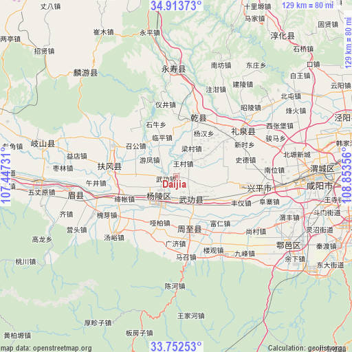
Daijia GPS coordinates[2]
34° 20' 6.504" North, 108° 9' 1.548" East
| Map corner | latitude | longitude |
|---|---|---|
| Upper-left | 34.91373°, | 107.44731° |
| Center: | 34.33514°, | 108.15043° |
| Lower-right: | 33.75253°, | 108.85356° |
| Map W x H: | 129.1×129.1 km | = 80.2×80.2mi |
| max Lat: | 53.31946° ⇑28.3% North |
| Daijia: | 34.33514° |
| min Lat: | ⇓71.7% South 18.22056° |
| min Long | Daijia | max Long |
| 75.07348° | 108.15043° | 134.28917° |
| W 20%⇐ | ⇒80% E |
Elevation
Elevation of Daijia is 527 m = 1729 ft, and this is 42.2 m = 138 ft above average elevation for this country.
| Max E: |
5622 m = 18445 ft | 24.8% |
| Daijia | 527 m 1729 ft | |
| Avg. | 484.8 m = 1591 ft | |
Min E: |
-3 m = -10 ft | 75.2% |
See also: China elevation on elevation.city.
Geographical zone
Daijia is located in North temperate zone (between Tropic of Cancer and the Arctic Circle). Distance of this Northern Tropic circle is 1211.8 km =753 mi to South.| Distance of | km | miles | from Daijia |
|---|---|---|---|
| North Pole | 6189.4 | 3845.9 | to North |
| Arctic Circle | 3583.5 | 2226.7 | to North |
| Tropic Cancer | 1211.8 | 753 | to South |
| Equator | 3817.7 | 2372.2 | to South |


Nearby cities:
15 places around Daijia: (largest is in red/bold)
• Changning
13.5 km =8.4 mi,  106°
106°
• Dazhuang
9.2 km =5.7 mi,  173°
173°
• Jiangcun
11.4 km =7.1 mi,  55°
55°
• Pujijie
14.3 km =8.9 mi,  142°
142°
• Sufang
9.1 km =5.7 mi,  318°
318°
• Wangcun
5.4 km =3.4 mi,  32°
32°
• Wugong
4 km =2.5 mi,  259°
259°
• Wugong
10 km =6.2 mi,  148°
148°
• Wuquan
14.9 km =9.3 mi, 255°
• Xiaocun
12.9 km =8 mi,  127°
127°
• Xinglin
14.7 km =9.1 mi,  273°
273°
• Yangling
9.6 km =6 mi,  222°
222°
• Youfeng
11.6 km =7.2 mi,  302°
302°
• Zhenyuan
4.7 km =2.9 mi,  103°
103°
• Zhoucheng
11.6 km =7.2 mi,  346°
346°
Sources, notices
• [Note1] Compared only with cities in China existing in our database
• [Src1] Map data: © OpenStreetMap contributors (CC-BY-SA)
• [Src2] Other city data from geonames.org with taken over terms of usage.
• [Src3] Geographical zone / Annual Mean Temperature by Robert A. Rohde @ Wikipedia
