Changning geodata
Changning (Shaanxi) is a seat of a fourth-order administrative division; located in China in Asia/Shanghai (GMT+8) time zone. In our database, there are 1268 cities with bigger population. Compared to other cities in China, 71.5% of cities are located further ↓South; 79.5% of cities are located further →East and 71.7% of cities have lower elevation than Changning. Note1


Changning GPS coordinates[2]
34° 18' 5.472" North, 108° 17' 28.5" East
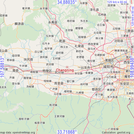
| Map corner | latitude | longitude |
|---|---|---|
| Upper-left | 34.88035°, | 107.58813° |
| Center: | 34.30152°, | 108.29125° |
| Lower-right: | 33.71868°, | 108.99438° |
| Map W x H: | 129.2×129.2 km | = 80.3×80.3mi |
| max Lat: | 53.31946° ⇑28.5% North |
| Changning: | 34.30152° |
| min Lat: | ⇓71.5% South 18.22056° |
| min Long | Changning | max Long |
| 75.07348° | 108.29125° | 134.28917° |
| W 20.5%⇐ | ⇒79.5% E |
Elevation
Elevation of Changning is 447 m = 1467 ft, and this is 37.8 m = 124 ft below average elevation for this country.
| Max E: |
5622 m = 18445 ft | 28.3% |
| Avg. | 484.8 m = 1591 ft | |
| Changning | 447 m = 1467 ft | |
Min E: |
-3 m = -10 ft | 71.7% |
See also: China elevation on elevation.city.
Geographical zone
Changning is located in North temperate zone (between Tropic of Cancer and the Arctic Circle). Distance of this Northern Tropic circle is 1208.1 km =750.7 mi to South.| Distance of | km | miles | from Changning |
|---|---|---|---|
| North Pole | 6193.1 | 3848.2 | to North |
| Arctic Circle | 3587.2 | 2229 | to North |
| Tropic Cancer | 1208.1 | 750.7 | to South |
| Equator | 3814 | 2369.9 | to South |


Nearby cities:
15 places around Changning: (largest is in red/bold)
• Daijia
13.5 km =8.4 mi,  286°
286°
• Dazhuang
13 km =8.1 mi,  245°
245°
• Fengyi
12.5 km =7.8 mi,  117°
117°
• Jiangcun
10.8 km =6.7 mi,  340°
340°
• Malian
8.5 km =5.3 mi,  27°
27°
• Mawei
7.6 km =4.7 mi,  77°
77°
• Pujijie
8.7 km =5.4 mi,  209°
209°
• Sangzhen
7.1 km =4.4 mi,  135°
135°
• Tangfang
9.7 km =6 mi, 137°
• Wangcun
13.1 km =8.1 mi,  309°
309°
• Wugong
9.1 km =5.7 mi,  238°
238°
• Xiaocun
5 km =3.1 mi, 213°
• Xicheng
13.8 km =8.6 mi,  86°
86°
• Xuelu
12.8 km =8 mi,  20°
20°
• Zhenyuan
8.8 km =5.5 mi, 287°
Sources, notices
• [Note1] Compared only with cities in China existing in our database
• [Src1] Map data: © OpenStreetMap contributors (CC-BY-SA)
• [Src2] Other city data from geonames.org with taken over terms of usage.
• [Src3] Geographical zone / Annual Mean Temperature by Robert A. Rohde @ Wikipedia
