Yong’an geodata
Yong’an (Inner Mongolia) is a seat of a fourth-order administrative division; located in China in Asia/Shanghai (GMT+8) time zone. In our database, there are 1268 cities with bigger population. Compared to other cities in China, 94.7% of cities are located further ↓South; 90.5% of cities are located further ←West and 67.2% of cities have lower elevation than Yong’an. Note1


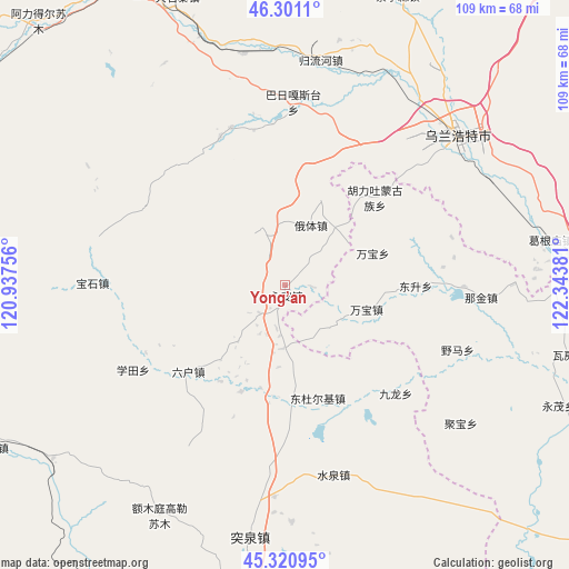
Yong’an GPS coordinates[2]
45° 48' 47.448" North, 121° 38' 26.448" East
| Map corner | latitude | longitude |
|---|---|---|
| Upper-left | 46.3011°, | 120.93756° |
| Center: | 45.81318°, | 121.64068° |
| Lower-right: | 45.32095°, | 122.34381° |
| Map W x H: | 109×109 km | = 67.7×67.7mi |
| max Lat: | 53.31946° ⇑5.3% North |
| Yong’an: | 45.81318° |
| min Lat: | ⇓94.7% South 18.22056° |
| min Long | Yong’an | max Long |
| 75.07348° | 121.64068° | 134.28917° |
| W 90.5%⇐ | ⇒9.5% E |
Elevation
Elevation of Yong’an is 362 m = 1188 ft, and this is 122.8 m = 403 ft below average elevation for this country.
| Max E: |
5622 m = 18445 ft | 32.8% |
| Avg. | 484.8 m = 1591 ft | |
| Yong’an | 362 m = 1188 ft | |
Min E: |
-3 m = -10 ft | 67.2% |
See also: China elevation on elevation.city.
Geographical zone
Yong’an is located in North temperate zone (between Tropic of Cancer and the Arctic Circle). Distance of this North polar circle is 2307.2 km =1433.6 mi to North.| Distance of | km | miles | from Yong’an |
|---|---|---|---|
| North Pole | 4913.1 | 3052.9 | to North |
| Arctic Circle | 2307.2 | 1433.6 | to North |
| Tropic Cancer | 2488 | 1546 | to South |
| Equator | 5093.9 | 3165.2 | to South |


Nearby cities:
15 places around Yong’an: (largest is in red/bold)
• Baoshi
36.7 km =22.8 mi,  270°
270°
• Dabagou
35.6 km =22.1 mi,  36°
36°
• Guji
30.7 km =19.1 mi,  336°
336°
• Heping
45.4 km =28.2 mi,  48°
48°
• Hulitu
23.2 km =14.4 mi, 48°
• Meiyao
15.3 km =9.5 mi,  102°
102°
• Ping’an
69.6 km =43.2 mi, 95°
• Shuiquan
37.8 km =23.5 mi,  159°
159°
• Shumugou
75.9 km =47.2 mi,  301°
301°
• Taodong
75.8 km =47.1 mi,  111°
111°
• Tule Mod
66.9 km =41.6 mi,  244°
244°
• Tuquan
45.7 km =28.4 mi,  183°
183°
• Ulanhot
45.5 km =28.3 mi, 48°
• Wafang
56.9 km =35.4 mi, 104°
• Xuetian
33.3 km =20.7 mi, 240°
Sources, notices
• [Note1] Compared only with cities in China existing in our database
• [Src1] Map data: © OpenStreetMap contributors (CC-BY-SA)
• [Src2] Other city data from geonames.org with taken over terms of usage.
• [Src3] Geographical zone / Annual Mean Temperature by Robert A. Rohde @ Wikipedia
