Ping’an geodata
Ping’an (Jilin) is a seat of a fourth-order administrative division; located in China in Asia/Shanghai (GMT+8) time zone. In our database, there are 1268 cities with bigger population. Compared to other cities in China, 94.6% of cities are located further ↓South; 92.2% of cities are located further ←West and 53.1% of cities have lower elevation than Ping’an. Note1


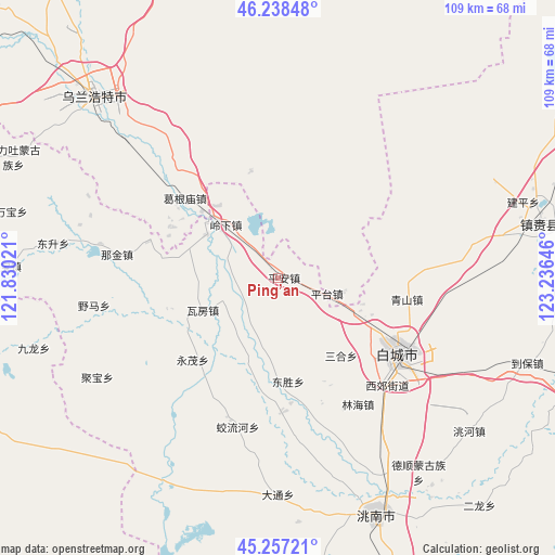
Ping’an GPS coordinates[2]
45° 45' 0" North, 122° 31' 59.988" East
| Map corner | latitude | longitude |
|---|---|---|
| Upper-left | 46.23848°, | 121.83021° |
| Center: | 45.75°, | 122.53333° |
| Lower-right: | 45.25721°, | 123.23646° |
| Map W x H: | 109.1×109.1 km | = 67.8×67.8mi |
| max Lat: | 53.31946° ⇑5.4% North |
| Ping’an: | 45.75° |
| min Lat: | ⇓94.6% South 18.22056° |
| min Long | Ping’an | max Long |
| 75.07348° | 122.53333° | 134.28917° |
| W 92.2%⇐ | ⇒7.8% E |
Elevation
Elevation of Ping’an is 189 m = 620 ft, and this is 295.8 m = 970 ft below average elevation for this country.
| Max E: |
5622 m = 18445 ft | 46.9% |
| Avg. | 484.8 m = 1591 ft | |
| Ping’an | 189 m = 620 ft | |
Min E: |
-3 m = -10 ft | 53.1% |
See also: China elevation on elevation.city.
Geographical zone
Ping’an is located in North temperate zone (between Tropic of Cancer and the Arctic Circle). Distance of this North polar circle is 2314.3 km =1438 mi to North.| Distance of | km | miles | from Ping’an |
|---|---|---|---|
| North Pole | 4920.1 | 3057.2 | to North |
| Arctic Circle | 2314.3 | 1438 | to North |
| Tropic Cancer | 2481 | 1541.6 | to South |
| Equator | 5086.9 | 3160.9 | to South |


Nearby cities:
15 places around Ping’an: (largest is in red/bold)
• Baicheng
27.4 km =17 mi,  125°
125°
• Dabagou
59.5 km =37 mi,  306°
306°
• Deshun
45.9 km =28.5 mi,  144°
144°
• Guangming
50.3 km =31.3 mi,  157°
157°
• Heping
51.4 km =31.9 mi,  316°
316°
• Hulitu
56.2 km =34.9 mi,  293°
293°
• Linhai
30.8 km =19.1 mi,  146°
146°
• Meiyao
54.4 km =33.8 mi,  273°
273°
• Mingren
28.2 km =17.5 mi, 128°
• Pingtai
9.8 km =6.1 mi,  112°
112°
• Qingshan
25.6 km =15.9 mi,  93°
93°
• Taodong
20.4 km =12.7 mi,  176°
176°
• Ulanhot
50.8 km =31.6 mi, 316°
• Wafang
16 km =9.9 mi,  242°
242°
• Zhenlai
60.2 km =37.4 mi,  79°
79°
Sources, notices
• [Note1] Compared only with cities in China existing in our database
• [Src1] Map data: © OpenStreetMap contributors (CC-BY-SA)
• [Src2] Other city data from geonames.org with taken over terms of usage.
• [Src3] Geographical zone / Annual Mean Temperature by Robert A. Rohde @ Wikipedia
