Ulanhot geodata
Ulanhot (Inner Mongolia) is a populated place; located in China in Asia/Shanghai (GMT+8) time zone. With population of 165,846 people, there are 267 cities with bigger population in this country. Compared to other cities in China, 95.1% of cities are located further ↓South; 91.3% of cities are located further ←West and 63.4% of cities have lower elevation than Ulanhot. Note1


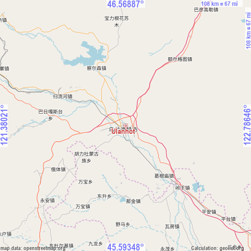
Ulanhot GPS coordinates[2]
46° 4' 59.988" North, 122° 4' 59.988" East
| Map corner | latitude | longitude |
|---|---|---|
| Upper-left | 46.56887°, | 121.38021° |
| Center: | 46.08333°, | 122.08333° |
| Lower-right: | 45.59348°, | 122.78646° |
| Map W x H: | 108.5×108.5 km | = 67.4×67.4mi |
| max Lat: | 53.31946° ⇑4.9% North |
| Ulanhot: | 46.08333° |
| min Lat: | ⇓95.1% South 18.22056° |
| min Long | Ulanhot | max Long |
| 75.07348° | 122.08333° | 134.28917° |
| W 91.3%⇐ | ⇒8.7% E |
Elevation
Elevation of Ulanhot is 303 m = 994 ft, and this is 181.8 m = 596 ft below average elevation for this country.
| Max E: |
5622 m = 18445 ft | 36.6% |
| Avg. | 484.8 m = 1591 ft | |
| Ulanhot | 303 m = 994 ft | |
Min E: |
-3 m = -10 ft | 63.4% |
See also: Ulanhot elevation on elevation.city.
Geographical zone
Ulanhot is located in North temperate zone (between Tropic of Cancer and the Arctic Circle). Distance of this North polar circle is 2277.2 km =1415 mi to North.| Distance of | km | miles | from Ulanhot |
|---|---|---|---|
| North Pole | 4883.1 | 3034.2 | to North |
| Arctic Circle | 2277.2 | 1415 | to North |
| Tropic Cancer | 2518.1 | 1564.7 | to South |
| Equator | 5124 | 3183.9 | to South |


Nearby cities:
15 places around Ulanhot: (largest is in red/bold)
• Baoshi
76.8 km =47.7 mi,  247°
247°
• Bayan Gol
61.9 km =38.5 mi,  29°
29°
• Dabagou
13 km =8.1 mi,  263°
263°
• Guji
46.3 km =28.8 mi,  267°
267°
• Heping
0.6 km =0.4 mi,  304°
304°
• Hulitu
22.4 km =13.9 mi,  228°
228°
• Meiyao
38.6 km =24 mi,  210°
210°
• Pingtai
59.9 km =37.2 mi,  132°
132°
• Ping’an
50.8 km =31.6 mi,  136°
136°
• Qingshan
71.5 km =44.4 mi,  122°
122°
• Shuiquan
68.6 km =42.6 mi,  197°
197°
• Taodong
67.9 km =42.2 mi,  147°
147°
• Tumuji
71.8 km =44.6 mi,  73°
73°
• Wafang
49 km =30.4 mi,  155°
155°
• Yong’an
45.5 km =28.3 mi, 228°
Sources, notices
• [Note1] Compared only with cities in China existing in our database
• [Src1] Map data: © OpenStreetMap contributors (CC-BY-SA)
• [Src2] Other city data from geonames.org with taken over terms of usage.
• [Src3] Geographical zone / Annual Mean Temperature by Robert A. Rohde @ Wikipedia
