Yangzhen geodata
Yangzhen (Beijing) is a seat of a fourth-order administrative division; located in China in Asia/Shanghai (GMT+8) time zone. In our database, there are 1268 cities with bigger population. Compared to other cities in China, 87% of cities are located further ↓South; 65.1% of cities are located further ←West and 72.3% of cities have higher elevation than Yangzhen. Note1


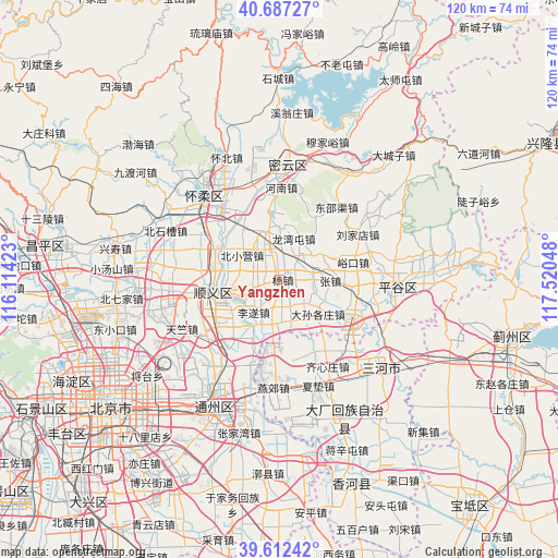
Yangzhen GPS coordinates[2]
40° 9' 7.092" North, 116° 49' 2.46" East
| Map corner | latitude | longitude |
|---|---|---|
| Upper-left | 40.68727°, | 116.11423° |
| Center: | 40.15197°, | 116.81735° |
| Lower-right: | 39.61242°, | 117.52048° |
| Map W x H: | 119.5×119.5 km | = 74.3×74.3mi |
| max Lat: | 53.31946° ⇑13% North |
| Yangzhen: | 40.15197° |
| min Lat: | ⇓87% South 18.22056° |
| min Long | Yangzhen | max Long |
| 75.07348° | 116.81735° | 134.28917° |
| W 65.1%⇐ | ⇒34.9% E |
Elevation
Elevation of Yangzhen is 44 m = 144 ft, and this is 440.8 m = 1446 ft below average elevation for this country.
| Max E: |
5622 m = 18445 ft | 72.3% |
| Avg. | 484.8 m = 1591 ft | |
| Yangzhen | 44 m = 144 ft | |
Min E: |
-3 m = -10 ft | 27.7% |
See also: China elevation on elevation.city.
Geographical zone
Yangzhen is located in North temperate zone (between Tropic of Cancer and the Arctic Circle). Distance of this Northern Tropic circle is 1858.6 km =1154.9 mi to South.| Distance of | km | miles | from Yangzhen |
|---|---|---|---|
| North Pole | 5542.6 | 3444 | to North |
| Arctic Circle | 2936.7 | 1824.8 | to North |
| Tropic Cancer | 1858.6 | 1154.9 | to South |
| Equator | 4464.5 | 2774.1 | to South |


Nearby cities:
15 places around Yangzhen: (largest is in red/bold)
• Beiwu
10.5 km =6.5 mi,  178°
178°
• Beixiaoying
9.7 km =6 mi,  301°
301°
• Liqiao
18.6 km =11.6 mi,  237°
237°
• Lisui
9.1 km =5.7 mi,  219°
219°
• Longwantun
8.6 km =5.3 mi,  23°
23°
• Machangying
16.9 km =10.5 mi,  95°
95°
• Mafang
18.2 km =11.3 mi,  116°
116°
• Mulin
10.6 km =6.6 mi,  343°
343°
• Nancai
10.5 km =6.5 mi,  260°
260°
• Niulanshan
15.7 km =9.8 mi, 296°
• Shengli
15.3 km =9.5 mi, 255°
• Shunyi
14.8 km =9.2 mi, 256°
• Ximapo
14.5 km =9 mi,  276°
276°
• Yukou
16.3 km =10.1 mi,  75°
75°
• Zhangzhen
11 km =6.8 mi,  93°
93°
Sources, notices
• [Note1] Compared only with cities in China existing in our database
• [Src1] Map data: © OpenStreetMap contributors (CC-BY-SA)
• [Src2] Other city data from geonames.org with taken over terms of usage.
• [Src3] Geographical zone / Annual Mean Temperature by Robert A. Rohde @ Wikipedia
